

I just returned home from an awesome trip to Ecuador and the Galapagos islands with my friend Michael Antonov. The idea of going to the Galapagos islands had been tossing around in my mind for many years. Like most people, I first heard about the Galapagos islands in high school when I read about Charles Darwin and his theory of the origin of species through natural selection. However, living in India at that point and never having traveled abroad, I had very little sense of world geography and the word Galapagos meant little more than a funny sounding foreign name. After I moved to the US, my knowledge of and interest in world geography, culture and history increased steadily. I first traveled to South America in 2012 through my MBA program and spent about 10 days in Buenos Aires and Mendoza and thoroughly enjoyed the experience. Movies such as Master and Commander featuring the Galapagos islands that show the landscape and the unique ecosystem, further piqued my interest.
What pushed me over the edge was a conversation with my friend Michael (who is an investor in several biotech companies working on extending human lifespan and perhaps more importantly, health span). The idea being to slow down or reverse the biological processes that cause us to become progressively more frail as we get older, so that people stay physically and mentally healthy, active right up until the end of their days. I also read a fascinating book by Andrew Steele called “Ageless – The New Science of Getting Older Without Getting Old”. I recognize that the idea of extending human lifespan or even health span is fraught with ethical and moral issues. A religiously minded person may object on the grounds that we shouldn’t be tinkering with god’s creation, while a secular person may be concerned about too many claimants on our planet’s finite resources or an unscrupulous dictator staying in power for much longer than what would otherwise be the case. Regardless of one’s position on these issues, understanding the changes that take place in our bodies as we age is fascinating in its own right. The book has a fascinating discussion on whether aging is a biological inevitability or merely a process that evolution overlooked because it only cares about how effectively we reproduce. I’ve summarized that argument here to avoid interrupting the flow of this post.
In the introduction to his book, Andrew talks about the giant tortoises that inhabit the Galapagos islands (“Galapagos” is an old Spanish word meaning “saddle”. When Spanish sailors arrived on the islands off the coast of Equator, the shells of giant tortoises reminded them of sway back saddles). When Charles Darwin visited the Galapagos islands in 1835, he was greeted by several unusual species, giant tortoises being one. He collected several specimens to return to England for further studies. One of these tortoises, Harriet, went on to become the oldest recorded Galapagos tortoise, finally succumbing to a heart attack at the ripe old age of 175, outliving Darwin by well over a century!
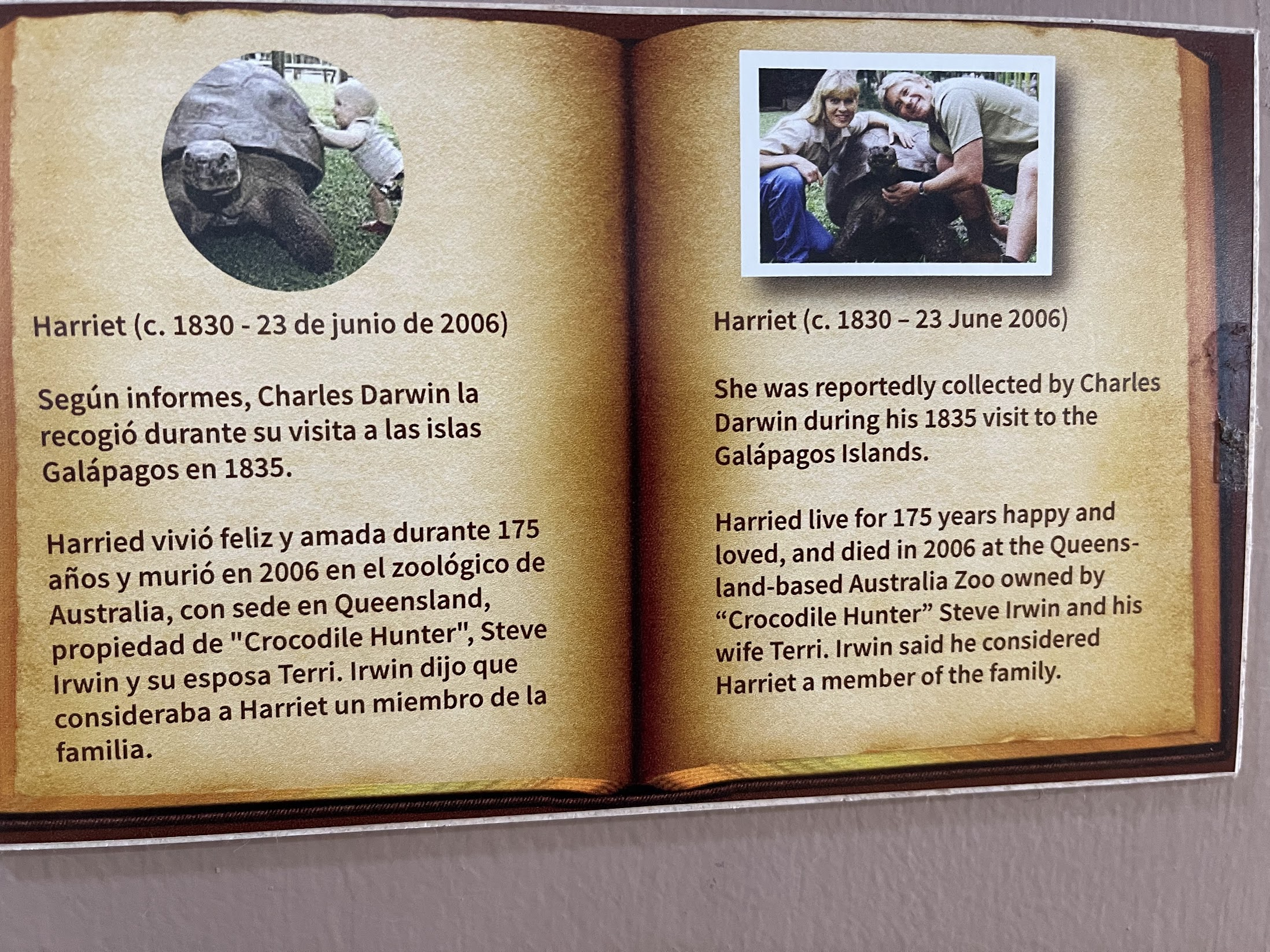
Further, these Galapagos tortoises, along with a few other species of tortoises and turtles, some fish, salamanders and a handful of other creatures display “negligible senescence” meaning they have no obvious impairment of movement or senses as they get older and they experience no age-related decline in fertility. I remember thinking – “wouldn’t it be great to see these tortoises for real!”.
The holidays are a great time to travel for me, because I don’t have immediate family in the US and spending the holidays by myself can be downright depressing, specially with omicron throwing a wet blanket on social activities yet again. Having decided to go, I discussed the idea with my long time friend and travel buddy Michael, and was delighted when he agreed to join me.

A quick note on writing this blog. It took me more than 2 weeks of work to finish this blog (~25 hrs total). It is a significant investment of time and energy, but I feel great after finishing it. It memorializes the experiences and helps improve my writing skills. When I read my own blogs even just one or two years later, I’m often surprised by how much I had forgotten, and also by the fact that sometimes all it takes is a small trigger to bring the memories flooding back.. meaning that the memories were still lingering in the recesses of my mind, but couldn’t be recalled without the right trigger. Writing about my travel experiences afterwards is also a great way of reliving the experience and seeing it in a different light. I do quite a bit of research about what I saw while writing these blogs and the learnings often trigger a feeling of “oh this is what that meant or why that is”, helping reinterpret or re-contextualize previous experiences.
Let’s begin by learning some basic facts about the Galapagos islands and then I’ll describe the trip itinerary, talk about what to bring, Covid testing requirements and the trade-offs involved between taking a cruise vs. island hopping. Then, I’ll go through the main activities of each day on a separate page, for easier readability.
Galapagos Islands: Basic facts
The Galapagos islands are an archipelago of volcanic islands. They are distributed on either side of the equator in the Pacific Ocean, surrounding the center of the Western Hemisphere, located 906 km (563 mi) west of continental Ecuador. The group consists of 18 main islands, 3 smaller islands, and 107 rocks and islets. The top 5 islands by land area are shown below
| Island name | Area (sq km) | Population |
|---|---|---|
| Isabela | 3670 | 1,748 |
| Santa Cruz | 986 | 12,000 |
| Fernandina | 642 | ~0 |
| Santiago | 572 | ~0 |
| San Cristobal | 557 | 6000 |
Isabela, the largest island by far, is very sparsely populated, because the island is home to 5 volcanoes and most of the land area is off limits to people.
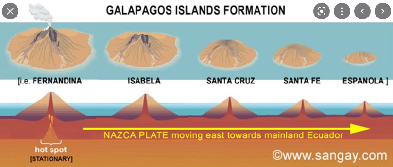
The process by which the Galapagos islands formed is similar to the Hawaiian archipelago. The Galapagos archipelago is located on the Nazca tectonic plate which is moving east/southeast, diving under the South American Plate at a rate of about 6.4 cm per year. This plate sits atop the Galápagos hotspot, a place where the Earth’s crust is being pushed up and melted from below by a mantle plume, creating volcanoes. Some of these volcanoes break through the ocean surface, forming islands. The islands get larger with each volcanic eruption. The eruptions continue as long as the island is on top of the mantle plume. Due to the movement of the tectonic plate, the island slowly moves away from the hot spot, making room for new islands to be formed by further volcanic activity. The older volcanoes eventually become inactive and weathering and erosion takes over. Plant life eventually establishes a toehold, starting from hardy cactus plants to Scalesia trees. Since the Galápagos Islands move with the Nazca plate in an east-southeast direction, the older islands such as Santa Cruz and San Cristobal are found in the southeast, while the newly forming islands such as Fernandina and Isabela are located in the northwest. The Galápagos Islands are some of the youngest landmasses known. The majority of the islands were formed less than one million years ago, the most recently formed island being Fernandina, at about 500,000 years old. Both Fernandina and Isabela islands are home to numerous active volcanoes.
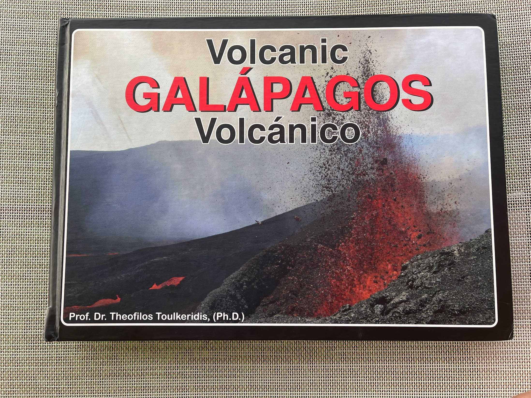
A small digression – on the cruise, there was an interesting book about Galapagos volcanoes that explains through illustrations and without too much jargon how various physical formations commonly seen on volcanic islands such as calderas, lava tubes and lava tunnels are formed. I recommend buying the book if you are interested in geology.
An interesting point I learnt from the book is that the Galapagos islands are formed by basalt, the most basic and most fluid, least viscous of all types of common lava. Because of its lower viscosity, this type of lava flows more easily and spreads over a large area around the source of the volcano, resulting in an edifice with low-angle slopes. These volcanoes are called shield volcanoes, because their gently sloping, convex profile resembles that of a Roman warrior’s shield. In contrast, lava from continental volcanoes is more viscous and solidifies quickly near the source rather than spreading across large distances. The highest volcano in the Galapagos, volcano Wolf is only 1710 m high, whereas mount Cotopaxi on the mainland is 5,897 metres, more than 3 times higher.
Visiting Ecuador and Galapagos islands
Galapagos islands are part of the country of Ecuador and the only way (that I know of) to get to the islands is to fly to either Baltra or San Cristobal islands from mainland Ecuador. You could also take a ship from Guayaquil, but that takes ~3 days and used primarily for cargo. Once on the Galapagos islands, there are two ways to travel around the archipelago – taking a cruise or island hopping. Taking a cruise involves spending 4-6 days on a medium-size boat with a capacity of ~25 passengers (not including the crew) and visiting 4-5 of the most interesting islands. The islands can be 50-70 Km from each other and the cruise ship covers most of this distance overnight, so you have the full day available for excursions. Cruises also include all food and equipment (kayaking, snorkeling, paddle boarding etc). Cruises however are more expensive – ~$3500 for a 5 day cruise.
Island hopping involves staying on one of the major islands (Isabela and Santa Cruz are two of the most popular choices), and taking a speed boat to the smaller islands, where most of the interesting animal life is found. A speed boat takes about 2 hrs to cover a distance of 70 km. The seas can be rough, so this can be a bumpy ride. Since it is not possible to stay on the smaller islands, you’d need to return back to home base, meaning that 4-5 hours of the day is spent on a boat. Therefore, if your goal is to see as much wild life as possible with the least hassle, I recommend taking the cruise. Mike and I ended up combining the cruise with island hopping. We took a cruise for 4 days and then spent a day each on Santa Cruz and Isabela islands. I strongly recommend this option if your schedule and budget allows.
There are several tour agencies that organize customizable tours of Galapagos islands along with popular cities in Ecuador such as Quito and Guayaquil. I chose this one. I’m very pleased with their planning, efficiency, choice of restaurants and overall responsiveness. If you haven’t visited Ecuador or Galapagos before, I recommend using a tour agency rather than trying to plan your own trip. This is because traveling around in Ecuador and specially in the Galapagos requires a lot of local knowledge. As an example, traveling from Isabela island to mainland Ecuador requires getting to the Puerto Villamil harbour from your hotel, boarding a water taxi that takes you to the speed boat, taking the speed boat to Santa Cruz island, transferring from the speed boat to water taxi that takes you to the Puerto Ayora harbour, taking a taxi across Santa Cruz island to the Santa Cruz ferry terminal, boarding a ferry to Baltra island, taking a bus from the ferry terminal to the airport and finally boarding a plane to Quito or Guayaquil. Each of these steps involves buying a ticket. There are only two speed boat schedules from Isabela to Santa Cruz, at 6AM and at 3PM. If you miss the morning ferry, you’d miss your flight to the mainland, throwing a wrinkle in your overall plans. Furthermore, English proficiency in the Galapagos islands is quite poor and if you don’t speak much Spanish (like Mike and I), you’ll struggle to figure out what to do.
The tour agency had knowledgeable and courteous guides meet us every step of the way. I had a guide meet me at the Quito airport when I landed at the airport, the same guide took us around Quito the first two days. When we went to the airport to catch our flight to Santa Cruz island, we were met by another guy who helped us get a boarding pass. Upon landing in Santa Cruz, we were met by the guide from the cruise, who gave us instructions on what to do next. While flying back to Ecuador mainland, there was an issue with my name. I emailed my contact at the agency and she had the issue resolved in minutes. You get the idea. The tour agency also made lunch and dinner reservations at excellent restaurants nearly every day of our trip. Having these details handled effectively goes a long way in letting you enjoy the sights and overall experience without constantly worrying about what’s coming next.
What to bring
Quito is located at an elevation of 2800 meters and only 25 km from the equator. Because of its high elevation and proximity to equator, Quito has consistent cool temperatures throughout the year. It has two seasons, dry (June through September, also called summer) and wet (rest of the year, also called winter). Funny that summer and winter are characterized by precipitation rather than temperature difference! The mean temperature is around 60 F (~14 degree Celsius), with the difference between the highest and lowest mean temperature per month over a whole year being as low as 0.3 degree centigrade. This means that jeans and t-shirt with perhaps a sweatshirt is all you need for Quito. It can get windy and misty in the highlands, so a waterproof wind breaker is good to bring also. If you are planning on hiking one of the many volcanoes around Quito, you need to bring the appropriate cold weather gear. As you can see in the pictures, I spent most of my time wearing jeans or shorts and t-shirt with my Capital One hoodie on top.
The temperature in the Galapagos islands hovers around 72 F all year around, so again short/jeans and t-shirt weather. Being located at the equator, sun is harsh, so definitely bring sunscreen and hat. You’d be doing a lot of walking, so bring sturdy sandals/shoes
The seas around the Galapagos islands can be rough. If you are prone to sea/motion sickness (like me), I highly recommend bringing a sea sickness medicine. Dramamine is a popular one, but it can cause drowsiness. The other well-known drug used to keep motion sickness under control is scopolamine. It’s an adhesive patch you put behind your ear a few hours before you think you’ll need it. You have to get a prescription for it. I used a scopolamine patch on the cruise and while taking the speed boat across Isabela and Santa Cruz, and it definitely kept me from throwing up a couple of times. Here’s a good article about how to prevent motion sickness.
Internet access on the Galapagos is spotty and non-existent while travelling between the islands, so be prepared to be offline for significant periods of time and bring a few good books.
To learn about the Galapagos islands, I purchased the lonely planet guide about Ecuador, which had some decent info about Quito and the Galapagos islands. I wish the lonely planet guides were shorter and talked more about the history, culture and experiences and less about restaurants and hotels, which one can look up easily in many other places. I also recommend the book below. It has great info about the plant/animal species found on the islands.
That’s pretty much it. It is good to travel light, specially if you are going to do island hopping as there is a lot of luggage transfer involved.
Covid testing requirements
The confusing and ever-changing testing requirements created by Covid-19 have made international travel more stressful and fraught with uncertainty. On the plus side, if you do manage to arrive at your destination, you avoid the crowds and enjoy in relative peace and quiet. Case in point, there were only 9 passengers on our cruise ship group when our boat could have accommodated around 20.
Traveling to Ecuador and Galapagos islands requires separate negative RT-PCR tests taken within 24 hours of the flight to each place. I had a scare because of confusion regarding the Covid testing requirements before my flight to Ecuador. See this post for details. I ended up getting the PCR test for Ecuador a day before my flight, and the tour agency arranged for a PCR test in Quito before the flight to Galapagos.
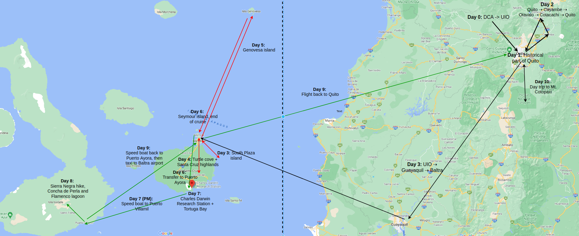
Trip itinerary
The map below shows our trip itinerary. Travels in mainland Ecuador are shown in black arrows, cruise itinerary in red arrows and island hopping activities in green arrows.
Brief history of Ecuador and Quito
The Incas ruled Quito and surrounding areas for about 50 years. In 1527, the Inca emperor Huayna Capac died unexpectedly. His death led to a bitter power struggle between his heirs Huáscar and Atahulpa. This struggle raged during the half-decade before the arrival of Francisco Pizarro‘s conquering expedition in 1532. Atahulpa eventually prevailed in this civil war. Upon hearing of the civil war and diseases (brought by the Spanish) destroying the Inca empire, Francisco Pizzaro and his men set out to meet the newly victorious Atahulpa. The two sides met around Cajamarca, Peru. Despite being vastly outnumbered, Pizarro’s troops under Fernando de Soto, thanks to superior weapons and tactics, defeated the Inca army and captured Atahulpa.
During the next year, Pizarro held Atahualpa for ransom. The Incas filled the ransom room with gold and silver awaiting a release, but on August 29, 1533 Atahualpa was executed. The Spanish then set out to conquer the rest of the Inca empire, capturing Cuzco in November 1533.
This wasn’t as simple of a story as Spanish conquistadors defeating native Indian tribes by the force of superior weapons, tactics and European germs. There were rivalries between the tribes themselves and several native tribes assisted the Spanish by showing them the way around hoping to enlist Spanish help to overthrow Inca rule. It is hard to say if this strategy of my enemy’s enemy is my friend served their long term interest.
From Cuzci, the Spanish rapidly expanded northward and in 1533, defeated the Inca general Rumiñahui who fell back to Quito and burned the city to prevent the Spanish from taking it, destroying the ancient pre-Hispanic city. The Spanish later used the ruins as construction material to build the several churches in old town Quito. This is the main reason it is difficult to find pre-columbian architecture in Quito.
By the 1570’s, the Spanish had conquered most of the Inca empire and installed themselves at the head of the political and economic hierarchy and co-opted the existing system of government to work in their interest.
Spanish colonial rule lasted nearly 300 years. The area of Ecuador, Peru, Columbia, Venezuela etc., were divided into vice-royalties with Spanish administrators at the top enforcing a system called encomienda, which meant virtual slavery for the native people of South America. This book has an insightful discussion on how the different economic systems in central and south America vs north America resulted in a divergent economic and political trajectory, the effects of which are still evident today.
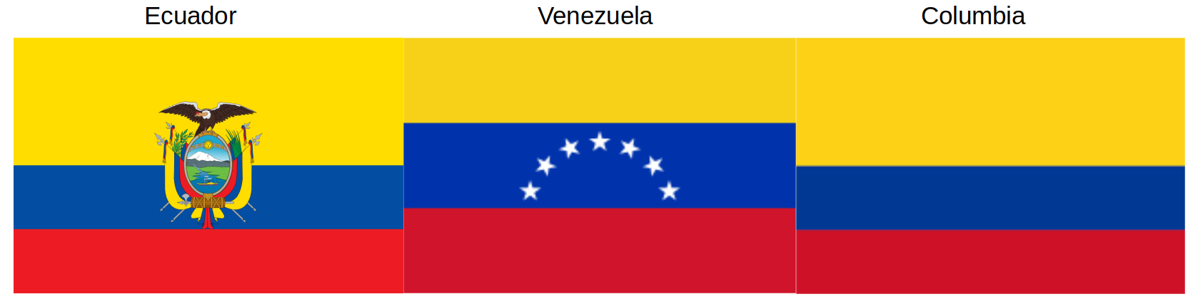
In the first two decades of the 19th century, independence movements erupted all over Northern South America. In 1821, Simon Bolivar and his troops defeated the Spaniards in the battle of New Granada and established the republic of Gran Columbia, comprising of present-day Colombia, mainland Ecuador (i.e. excluding the Galapagos Islands), Panama, and Venezuela, along with parts of northern Peru and northwestern Brazil. Gran Columbia didn’t last long. In 1830, its constituent republics withdrew and formed their own independent states, and this is how Ecuador came into being. The long shared history is reflected in the flags of Ecuador, Columbia, and Venezuela (same color stripes, different arms)
What happened next is long and tedious and not particularly interesting. I’ll refer you to the wikipedia article about Ecuador if you are interested
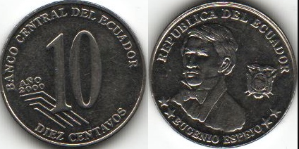
Interestingly, Ecuador is one of 7 countries that use the US Dollar as the official currency of exchange. In 1998, linked partly to the Asian economic crisis, Ecuador faced a difficult economic environment. Inflation raged wild and the Ecuadorian currency (called the Sucre) plummeted in value. To calm things down, Ecuador’s government replaced the local currency with the US dollar as a temporary measure. Initially, this resulted in severe economic hardship for the lower classes who lost significant wealth, but eventually resulted in resumption of economic growth. The only other country in South America that has adopted the US dollar is Panama.
US one dollar bills are not common in Ecuador, instead they prefer 1$ coins. They mint their own coins for fractional currency. The coins for 10 cents, 25 cents etc are minted locally and look different from US dime or quarter. They also have a locally minted coin for 50 cents.

Spanish is the official and most common language spoken in Ecuador. Northern Quechua and other pre-colonial American languages are spoken by about 15% of the population. From my very limited experience, English knowledge seemed to be low. We needed our guide to translate for us on many occasions, specially outside Quito.
I’ll now proceed to describe our main activities of each day, with lots of pictures and videos. Happy reading!
Leave a Reply