

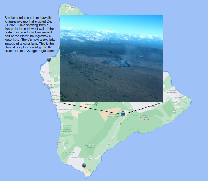
The holidays are typically not a particularly exciting time for me because my family lives far away and I’m usually by myself and holidays this year (2020) promised to be particularly bleak with the Covid-19 related lock downs and other restrictions on activities. So, when my friend Michael who lives in the bay area suggested visiting him in Hawaii where he had been living for a month to escape the strict lock downs in CA, I jumped on the offer right away. I had always wanted to go to Hawaii, to see Kīlauea, the volcano on Big Island (which interestingly, erupted right after I arrived!), hike, kitesurf and enjoy the island life for a bit.
A hiccup along the way to Hawaii was Covid testing. Hawaii requires a negative Covid test for all incoming travelers. The test must be taken 72 hours before departure and only at one of the approved test providers. Hawaii’s department of transportation publishes a list of approved providers. The majority of approved providers are on the West Coast, but there are a few on the East Coast, including CVS and Walgreens and American Family Care (AFC), an Urgent Care clinic. I wanted to get an appointment at CVS for a test, but you can only make an appointment for up to 2 days later (meaning that if I wanted to leave Dec 20, I could only make an appointment for Dec 17 (because the test must be taken in a 72 hr window before departure) latest on Dec 15, which is obviously cutting it close, because you don’t know if an appointment would be available..
Anyhow, I figured I’ll find some way to get a Covid test eventually so I went ahead and booked a flight on American Airlines to Honolulu, on Oahu island. During that process, I realized that major airlines had their own recommended methods to get a Covid test for flying to Hawaii. American was offering rapid Covid testing at select airports such as Dallas Fort Worth and partnering with LetsGetchecked, a company that offers at-home Covid tests by mail. To be safe, I ordered both an at-home test and made an appointment at the AFC in Edgewater, MD, about an hour drive from Rosslyn, hoping that one of two methods would work.
The LetsGetChecked kit arrived a day after I ordered. Since they know that you are getting tested for the purpose of traveling, they send an alert when the 72 hour window starts and you can activate the test. After you activate the test, you collect a nasal swab while under video supervision of one of their personnel and mail back the sample. To mail the sample back, they recommend setting up a UPS pickup, but I just dropped the sample off at the nearest UPS location for next day delivery (I wish they would make this process clearer) to their Covid testing lab. Once the sample is received by the lab, you get the results back within a few hours. You can check the status of your sample at every step in the process. I got my results back Saturday morning, a day before my flight. So I cancelled the appointment with AFC which was scheduled for later that day. Once you get the PDF of the test results, you need to upload it to the state of Hawaii department of transportation website, along with the rest of your travel info. If they PDF is properly formatted, you get a QR code, which needs to be shown when you arrive in Hawaii. The whole process was cumbersome and kind of annoying but it worked.
The next morning, I missed my original flight to Honolulu through LAX but thankfully was put on another flight through Dallas Fort Worth, which only added a couple of hours to my journey. The flight was long but uneventful. Upon arrival, they scanned by QR code and I was able to breeze through the Covid line.
Some basic facts about Hawaii. The Hawaiian islands consist of four main islands and several smaller ones. The four main islands (in order of land area) are:
- Hawaii (The Big Island): 4,028.0 sq mi, population: ~185K
- Maui (The Valley Isle): 727.2 sq mi, population: ~144K
- Oʻahu (The Gathering Place): 596.7 sq mi, population: ~ 953K. Capital Honolulu is located in Oʻahu
- Kauaʻi (The Garden Isle): 552.3 sq mi, population: 66K
According to the wikipedia article about Hawaii, the Hawaiian islands formed as the Pacific Plate slowly moved northwestward over a hotspot in the Earth’s mantle at a rate of approximately 32 miles per million years. Lava erupting out of this hotspot created the Hawaiian island chain. Thus, the southeast island of Hawaii (the big island) is the youngest (~400K years), still volcanically active and the biggest (shorter exposure to erosion), whereas the islands on the northwest end of the archipelago are older, typically smaller (due to longer exposure to erosion) and volcanically inactive. The oldest island (Kure Atoll) is estimated to be ~28 million years old. The big island also features the tallest peak in Hawaii – Mauna Kea at ~14000 feet. As thousands of residents of Pompei buried under lava and ash released by Mr. Vesuvius’s eruption in 79 AD can attest, volcanoes can be very destructive. And yet, they are also responsible for the creation of the magnificent Hawiian island chain along with so many other islands on earth!
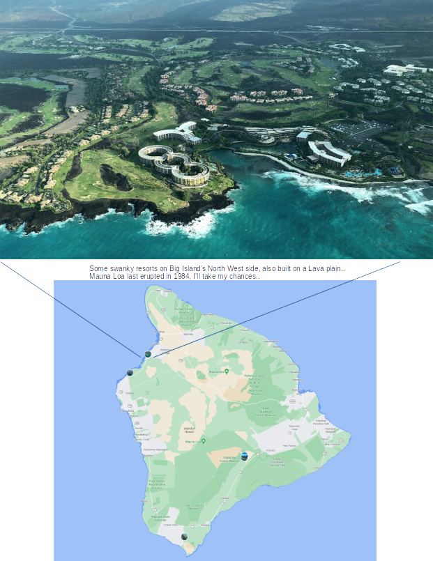
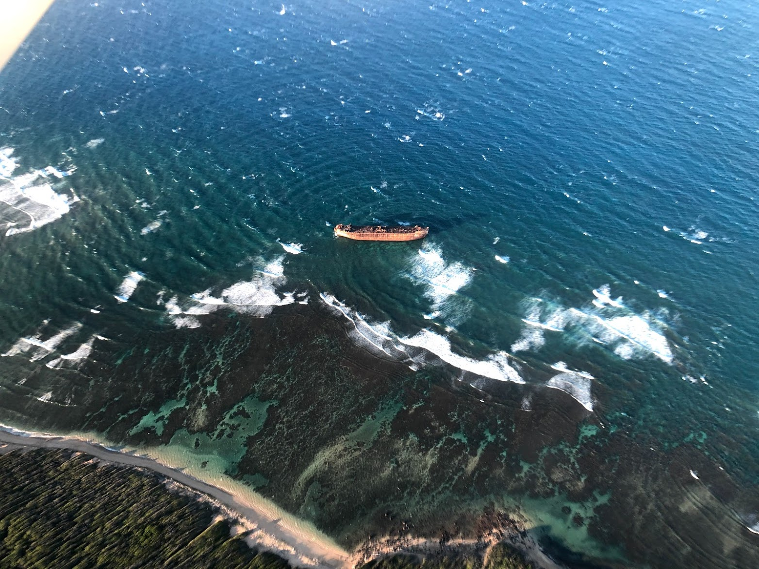
Aerial view of Hawaiian islands
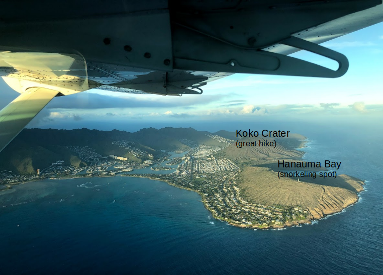
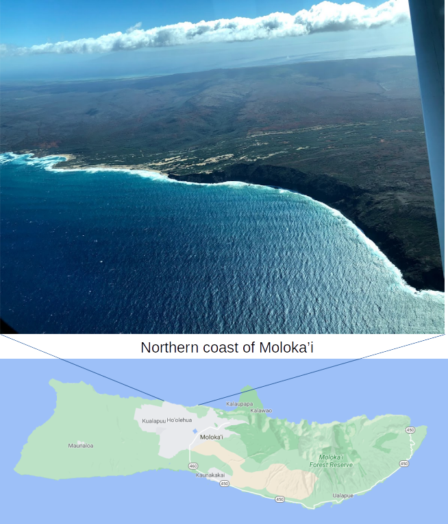
On day 10, we chartered a plane and flew over the islands of Oahu, Molokai, Maui, Big Island and Lanai. Some aerial photos are shown below.
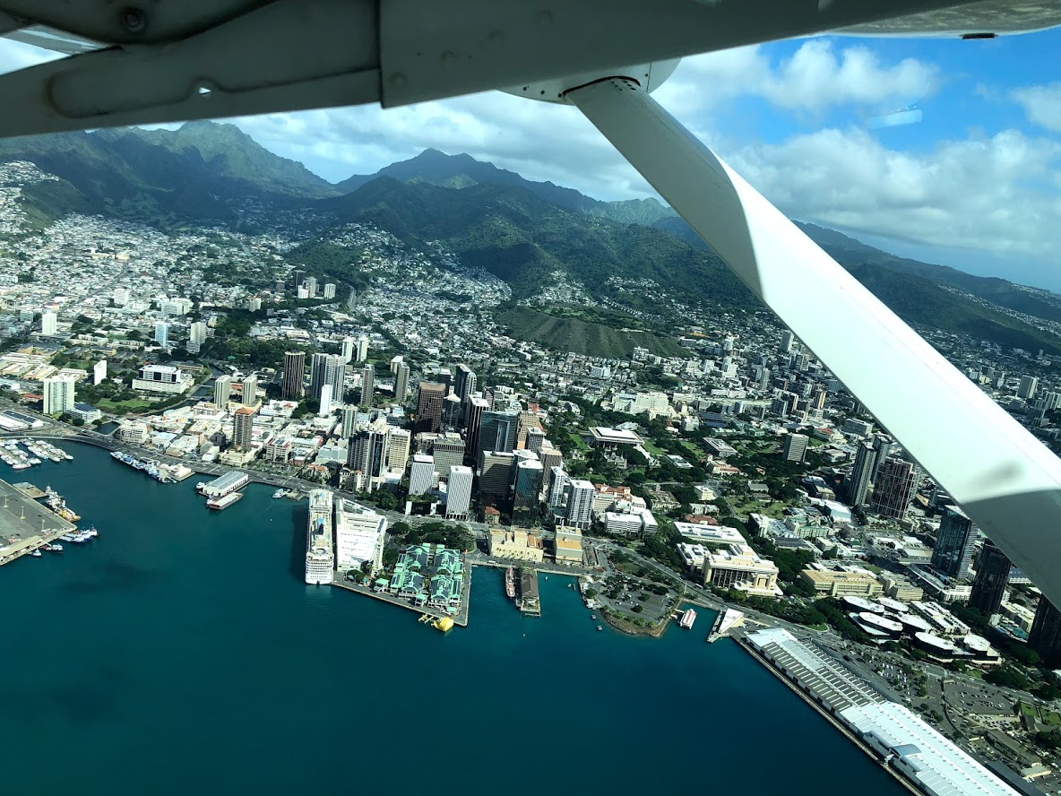

More pictures and an amazing video of Mount Haleakalā are shown under activities of day 10.
Brief history of Hawaii
Here’s a cliff notes version of Hawaiian history. First Polynesian settlers arrived on the Hawaiian islands around 1100 AD, as part of the final wave of Polynesian expansion (see Day 8 for more info about this). Hawaiian civilization was isolated from the rest of the world for the next 500 years. During this period, a central Hawaiian state did not exist, rather there were several tribes frequently at war with each other.
In 1778, Europeans led by British explorer James Cook showed up in Hawaii. With the help of European military technology, Kamehameha I, a nephew of the then king of the big island of Hawaii conquered and unified the islands for the first time, establishing the Kingdom of Hawaii in 1795. American immigration began almost immediately after Cook’s arrival, led by Protestant missionaries. Americans set up plantations to grow sugar, which required substantial labor. To meet this demand for labor, waves of permanent immigrants came from Japan, China, and the Philippines to work in the fields. By 1896, Hawaiians of Japanese descent comprised 25% of the population. Concurrent with this wave of immigration, the native population of Hawaii fell from around 150,000 in 1778 to 71,000 by 1853 because of various diseases such as bubonic plague, yellow fever brought by European settlers to which the native population had no immunity, along with declining birth rates and high infant mortality. Thus, the ethnic composition of Hawaii’s population was altered dramatically in a the course of just a few decades.
Various successors of Kamahameha ruled until 1893 when Hawaii was annexed by the United States. During this period, power gradually shifted from the monarchy to a wealthy European and American business class that raised the property ownership threshold required to vote, effectively disenfranchising a large part of the native and immigrant population. In 1893, queen Liliuokalani attempted to restore power back to the monarchy by promulgating a new constitution. This resulted in a coup which deposed the queen and ultimately led to annexation of Hawaii by the US in 1898 under president William McKinley. The annexation was hastened by the Spanish American war and attempts by Japan to acquire Hawaii for itself, a cause towards which Hawaiian population of Japanese descent was sympathetic. Finally, Hawaii was admitted as the 50th state on August 21, 1959, about 3 years before Barack Obama was born in Honolulu, Oahu.
Interesting facts about Hawaii
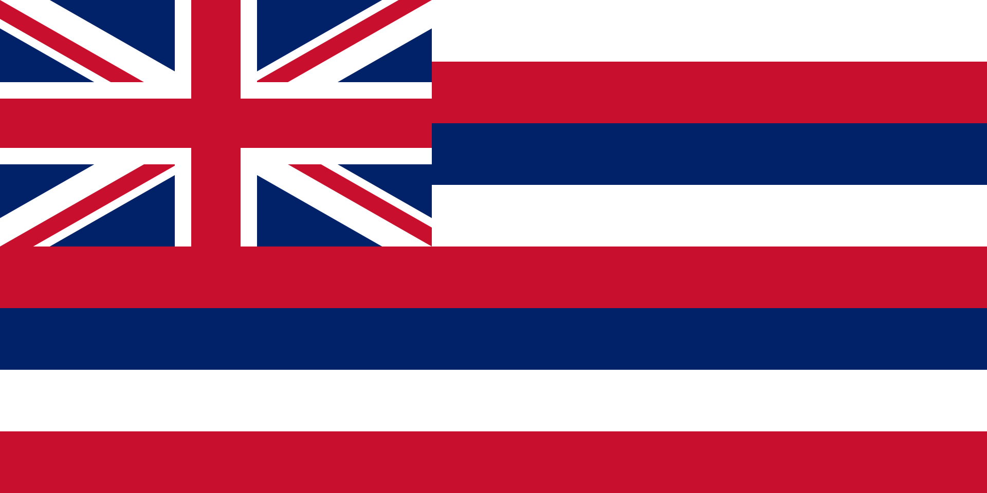
- Hawaii State Flag: is the only US state flag to include a foreign country’s national flag. The inclusion of the Union Jack of the United Kingdom is a mark of the British Empire’s historical relations with the Hawaiian Kingdom, particularly with King Kamehameha I
- The 6th biggest island in Hawaii, Lanai, is 98% owned by Larry Ellison, the former CEO of Oracle, who bought it in 2012 for 300M
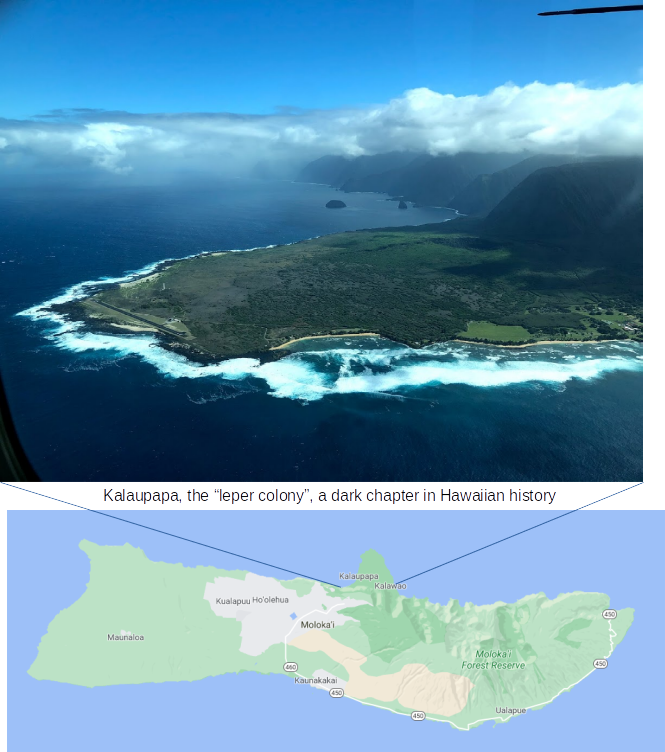
- The island of Molokai operated a leper colony from 1866 to 1969. More than 8500 men, women and children living throughout the Hawaiian islands and diagnosed with leprosy were exiled to the colony by the Hawaiian government and legally declared dead. This practice continued after the Hawaiian kingdom became a U.S. territory in 1898. Patients were not allowed to leave the settlement nor have visitors and had to live out their days here. In 1969 these forced quarantine were finally abolished although many residents of the colony chose to spend the rest of their days there
- Iolani Palace: Built in 1882, located in Honolulu, the Iolani palace served as the official residence of the Hawaiian monarchs until the overthrow of the Hawaiian monarchy. It is the only official royal residence in the United States
In the rest of the post, I’ll describe my activities on every day of this memorable trip. Hopefully you’ll find the information useful in planning your own Hawaiian adventure! For hiking, I highly recommend using alltrails.com and filtering for the level of difficulty, length, elevation gain etc., that you are comfortable with. There are dozens of amazing hikes of varying lengths and difficulty level all across the island. I’d recommend picking hikes all over the island because the terrain and thus the views vary a lot. Also, if a hike is rated hard on alltrails, then take the rating at its word! The hard (and even some of the moderate) hikes in Hawaii are no joke. You’ll go through some super steep ascents and descents, muddy terrain, thick, bushy undergrowth, walking along thin ridge lines with steep drops etc. In return you’d be treated to a breathtaking scenery of lush forests, rainbows, blue waters, lovely beaches, picturesque towns along with beautiful streams and waterfalls, wild flowers, mushrooms and much more. Hiking in Oahu was one of the highlights of my stay. Carry plenty of water, wear sturdy shoes and (I missed this one) wear hiking pants, specially on the ridge hikes. The undergrowth can be thick and wading through shrubs along narrow trails can be painful.
Day 1:
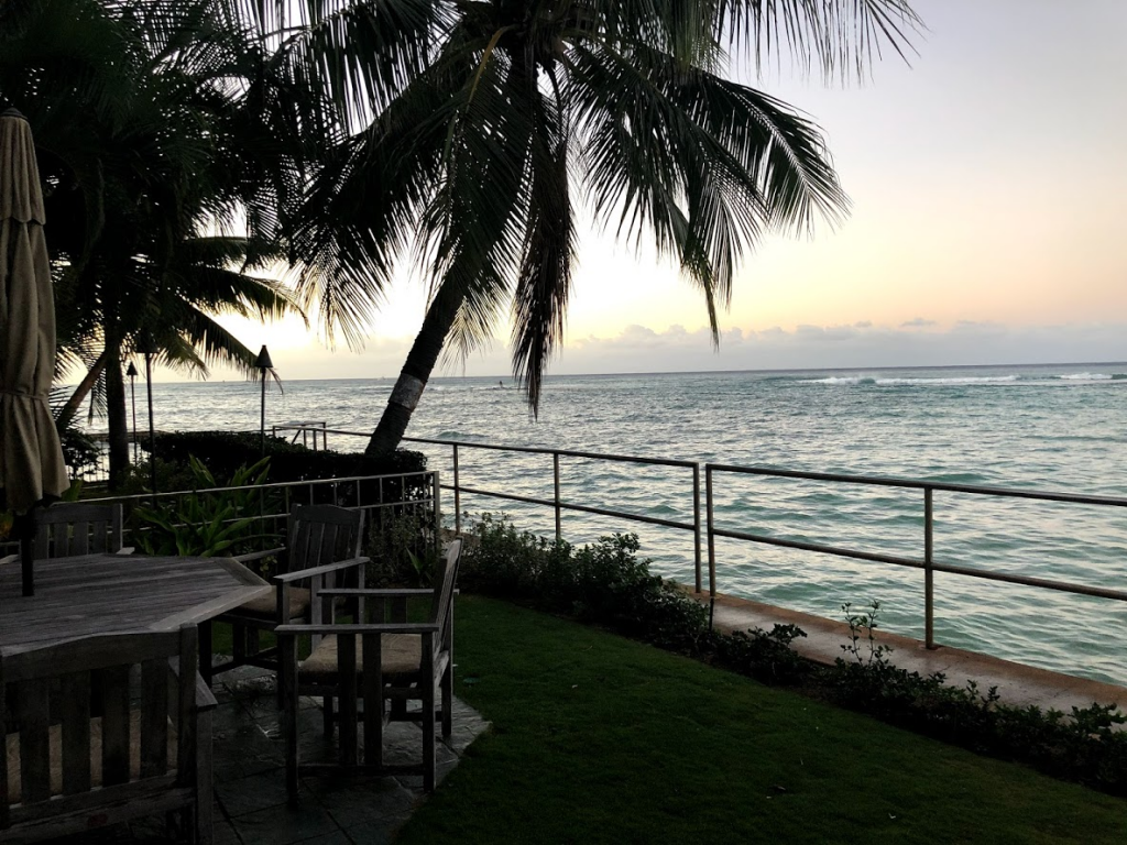
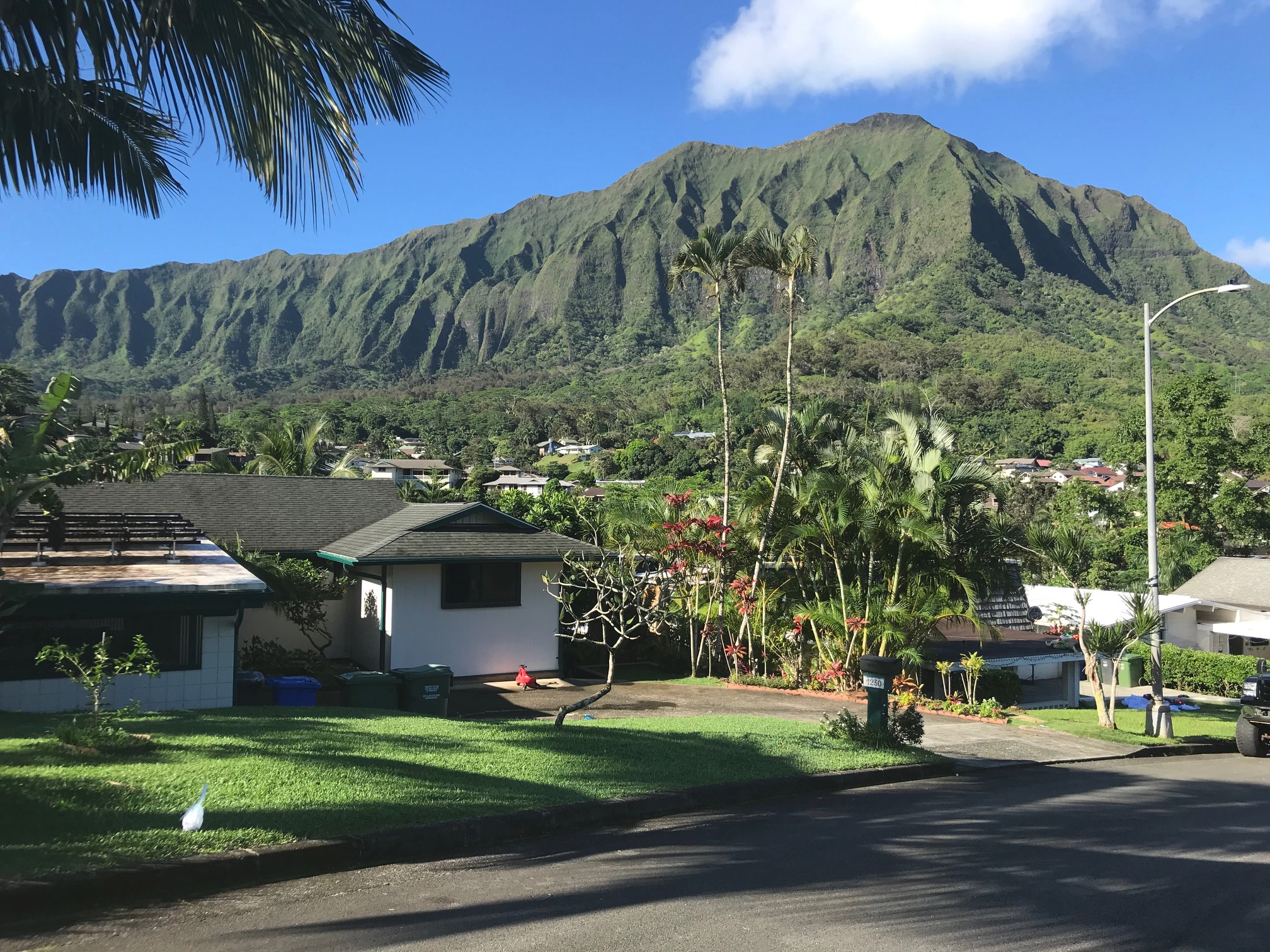
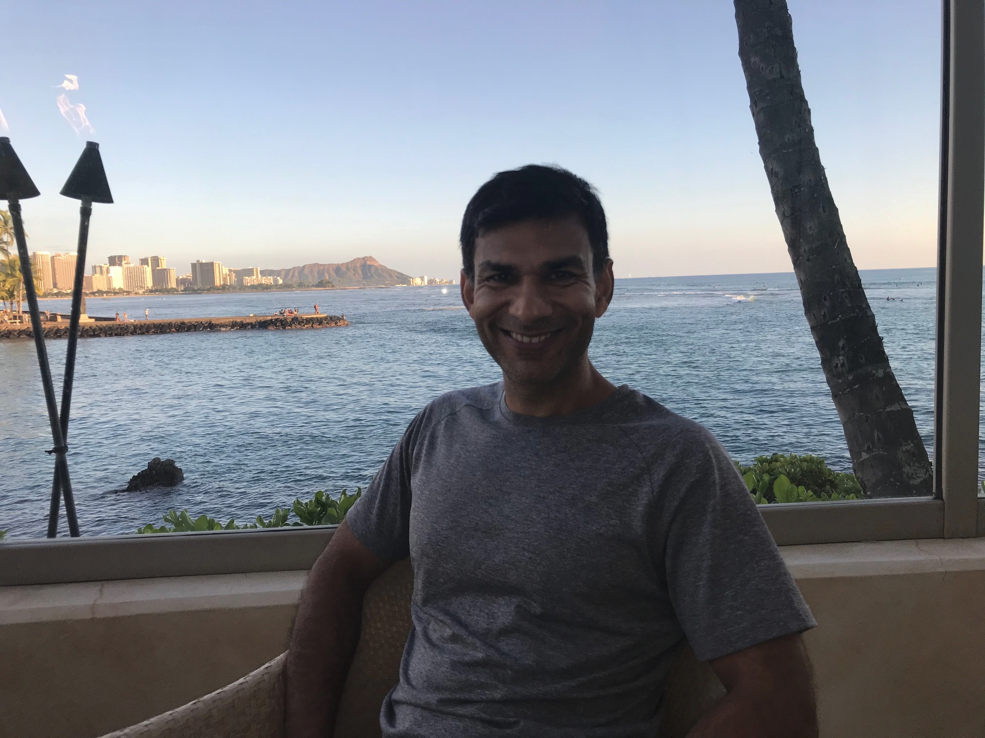
On my first full day in Hawaii, I woke up before sunrise, thank to the jet lag. I made my morning coffee, read “Why Nations Fail” (by Daron Acemoglu and James Rabinson) one of the three books I brought along on this trip and finished some work. It was breathtakingly beautiful and calming to see the morning light fill in and slowly light up the water around the house :-). Mike rented a beautiful three bedroom house right next to the water about a 20 min walk from downtown Honolulu. It was incredible to walk out into the back porch, coffee in hand and be treated to a view like this:
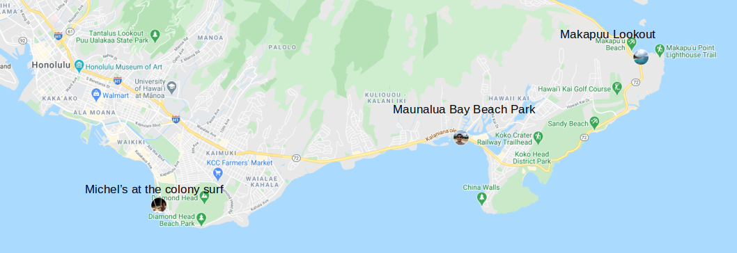
A bit later, I went out for a drive around the south coast of Oahu to the Marine Corps Base. I stopped at some lookout points along the way to take some pictures. Not sure why, but I was expecting Oahu to be a bit more rustic, however the general infrastructure seems very modern, a bit like Southern California.

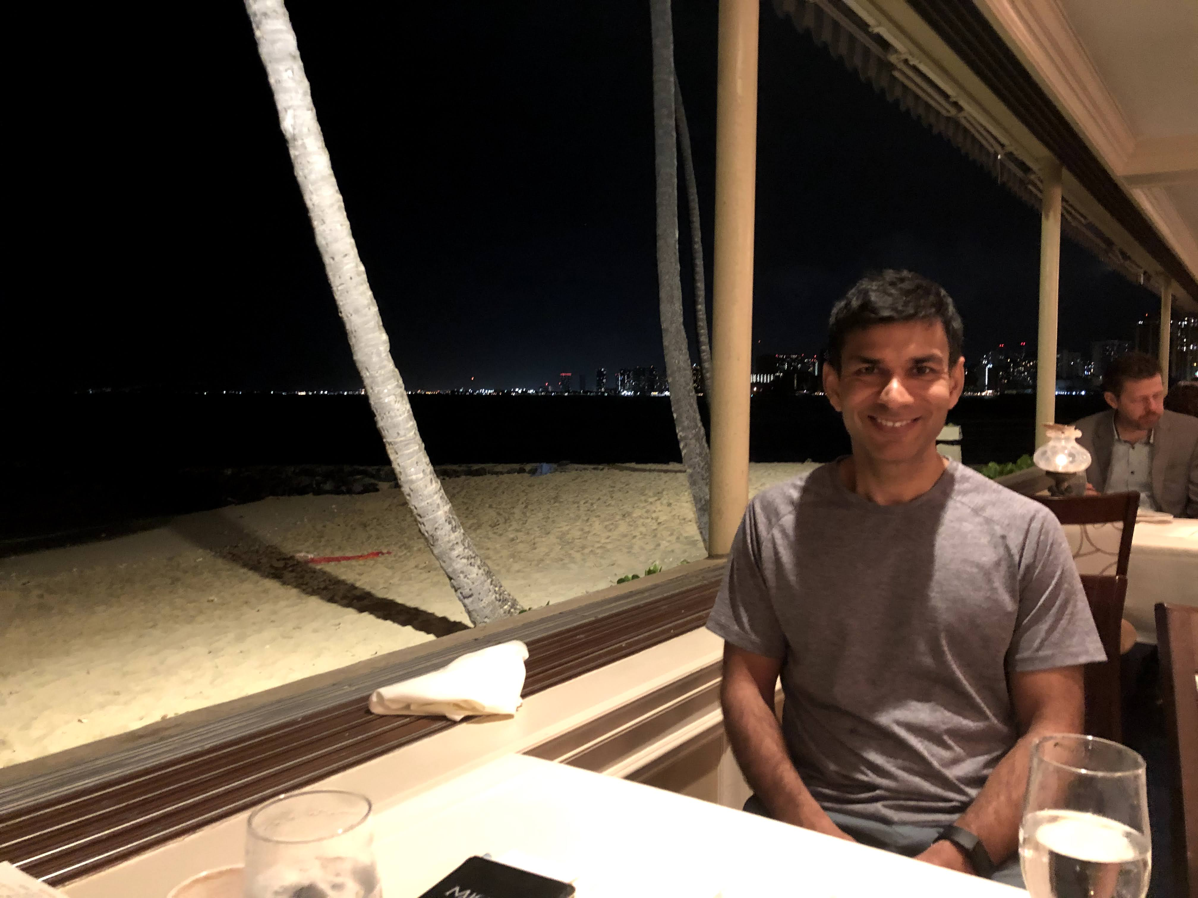
Later in the day, Michael and I went to a French restaurant nearby called Michel’s at the Colony Surf. The food and ambiance is excellent and I highly recommend the restaurant.
Day 2
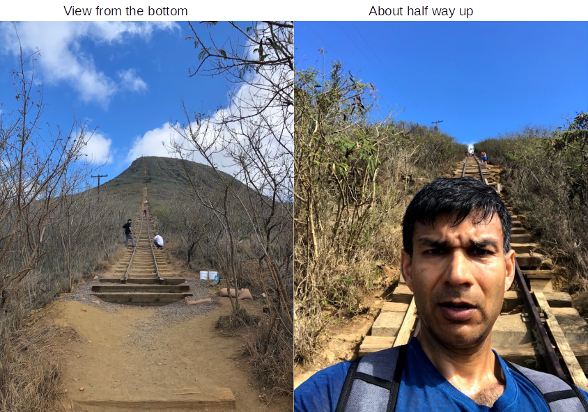
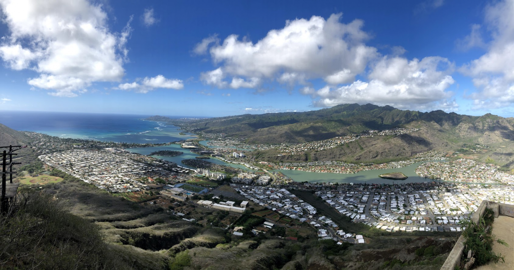
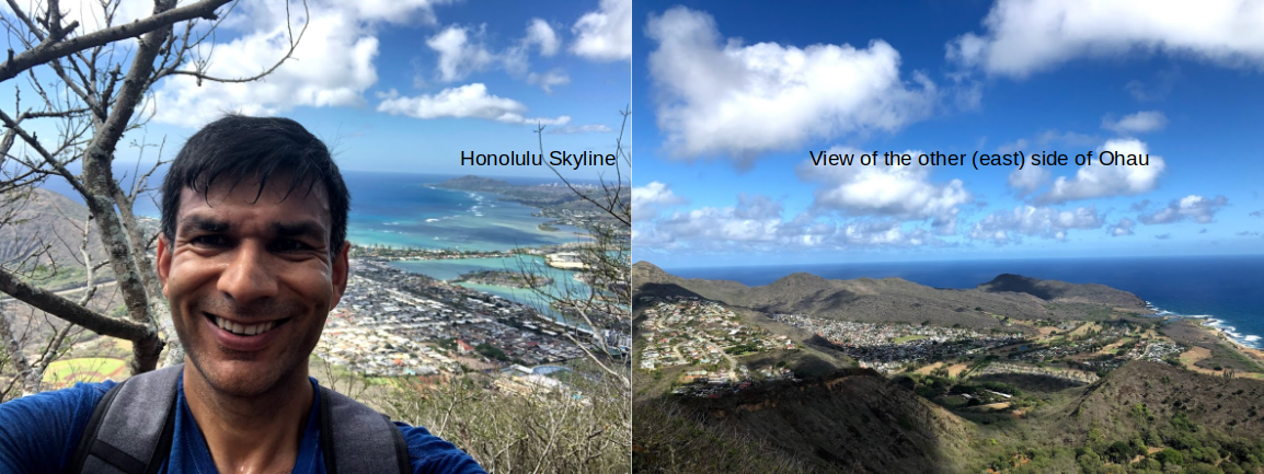
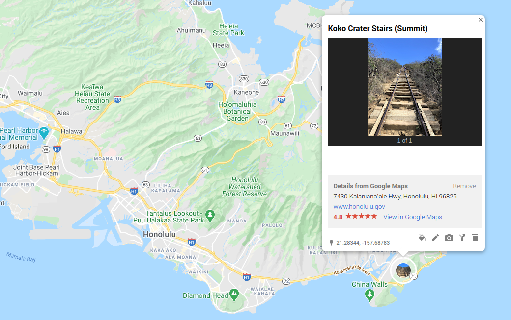
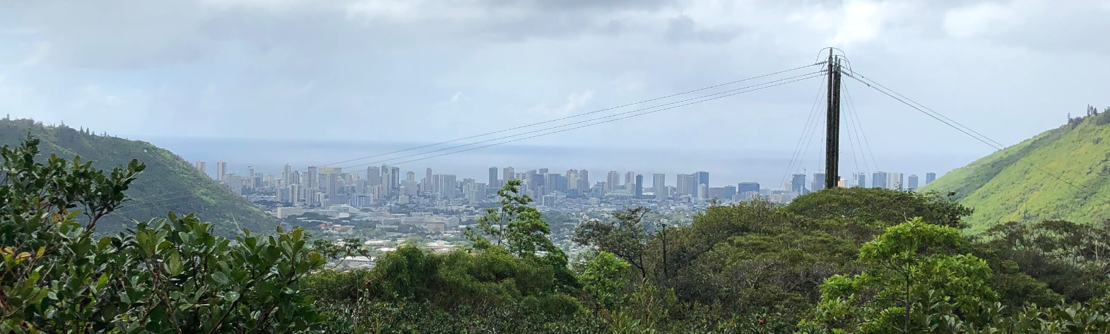
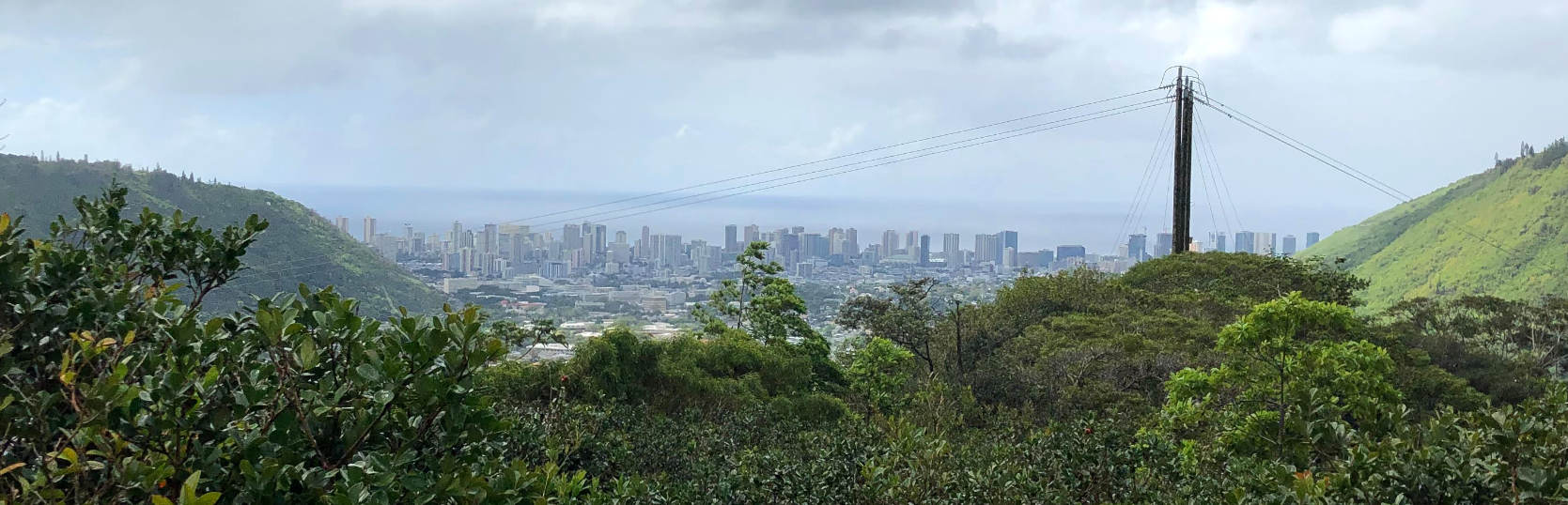
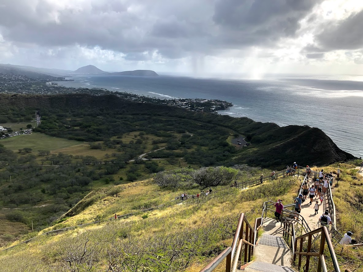
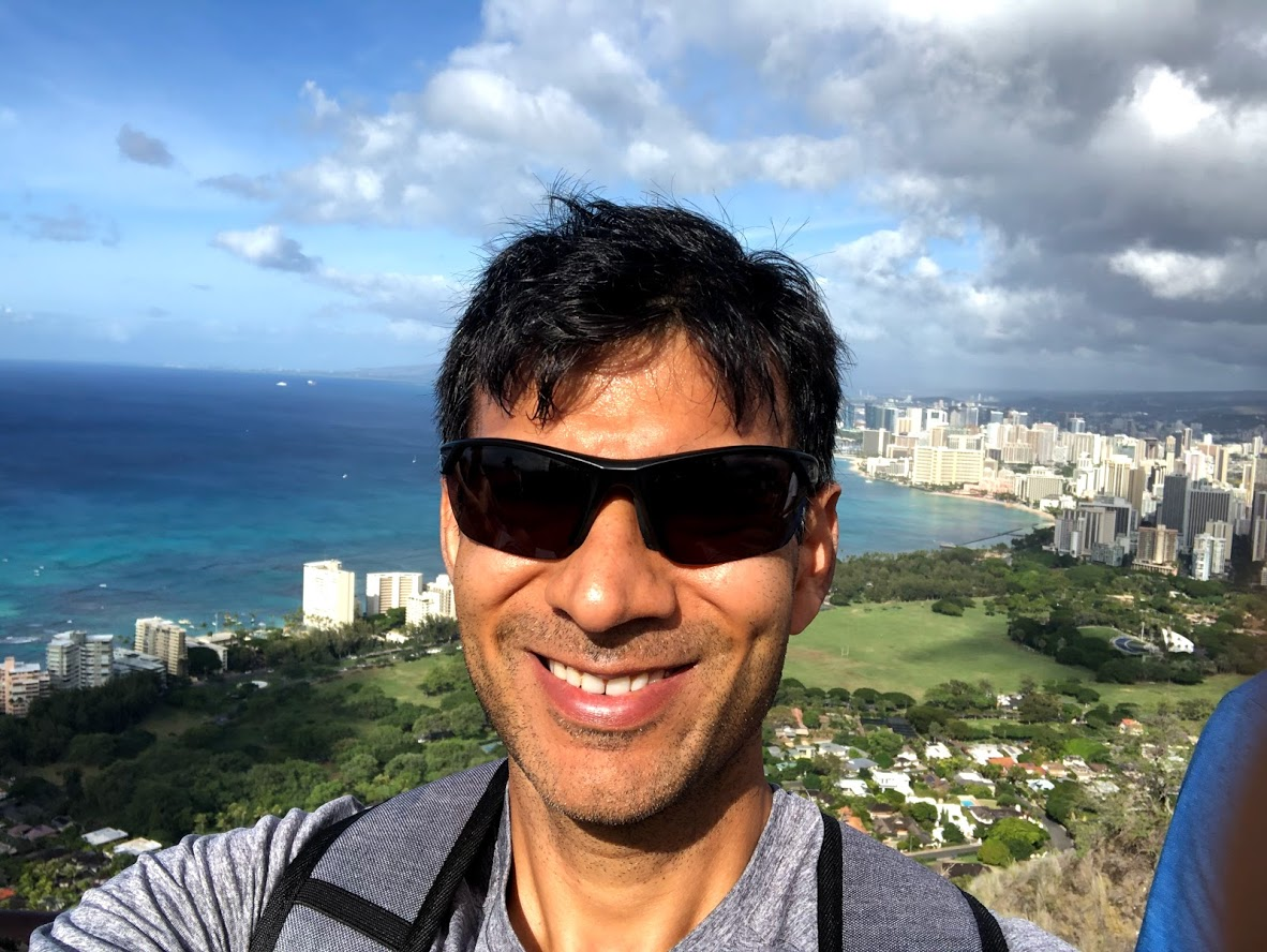
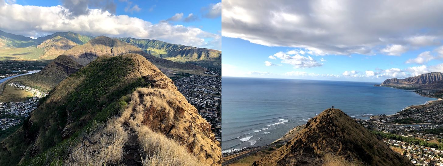
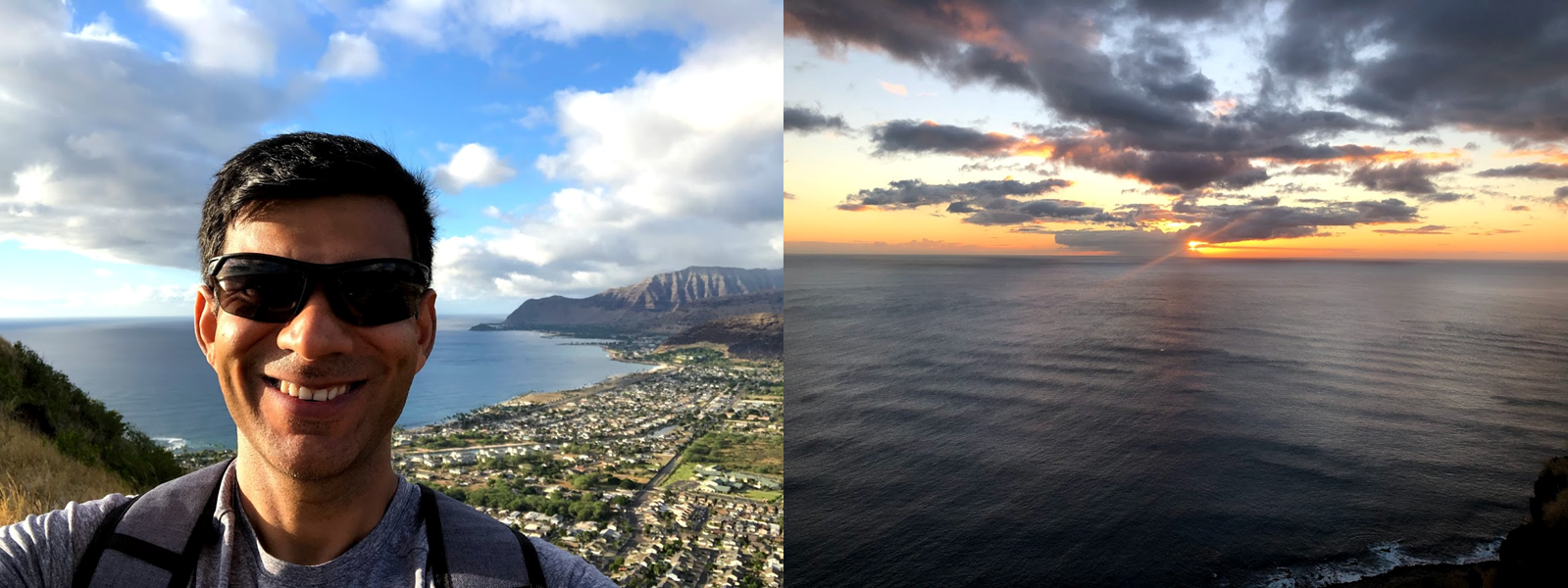
Morning of Day 2 was similar to Day 1. I woke up super early, read a bit, finished some work and then drove to the Diamond Head Beach Park to hike up to Diamond Head crater, a short drive away from the house. However, a bit to my disappointment, I found that the park was only open Thu through Sunday. I Googled around for other hikes to do and settled on the Koko crater lookout hike. This hike is a short but very steep climb that follows an abandoned railroad track to the top of Koko Head Crater with spectacular panoramic views of the southern part of Oahu, including the Honolulu skyline. The hike is ~1400 meters (one way) with an elevation gain of ~310 meters, implying a greater than 20% grade on average. I’m in pretty decent physical shape and this hike kicked my butt. I highly recommend eating a big breakfast and bringing plenty of water. It is also a good idea to start early in the morning before the sun is out in full force. The hike is very exposed and you’ll be sweating a lot. I made it to the top in a bit less than 30 minutes, which is a pretty good time. I overheard some people saying that the record is ~10 minutes for a man and ~13 minutes for a woman, both of which boggle my mind!
The view from the top is so worth it. See for yourself!
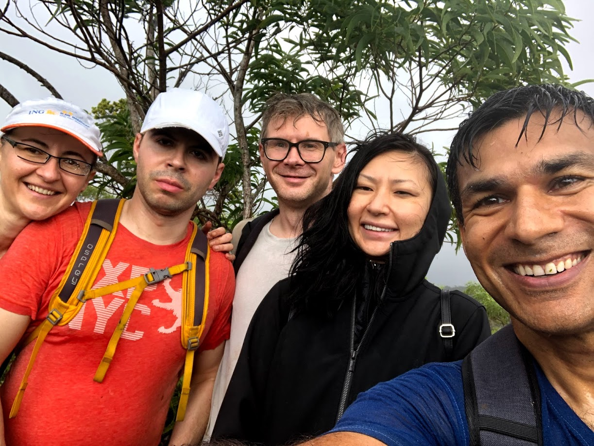
My friend Agnes arrived later in the day from Baltimore. She ran into some issues with her Covid test at the airport. Even though she got her test done at an approved Covid test clinic, her test results didn’t have some information required by Hawaii department of transportation. So she was put on a quarantine. Thankfully, she was able to contact the clinic the next day and get the required information and get off the quarantine.
For dinner, we walked over to a Thai restaurant in downtown Honolulu. Not sure why (perhaps because of the similar temperature), downtown Honolulu reminded me of Vegas. Lots of tourists, nice, but somewhat dated architecture, perfect temperature.. a big point of difference of course is Vegas is in a desert while Honolulu is right by the water 🙂
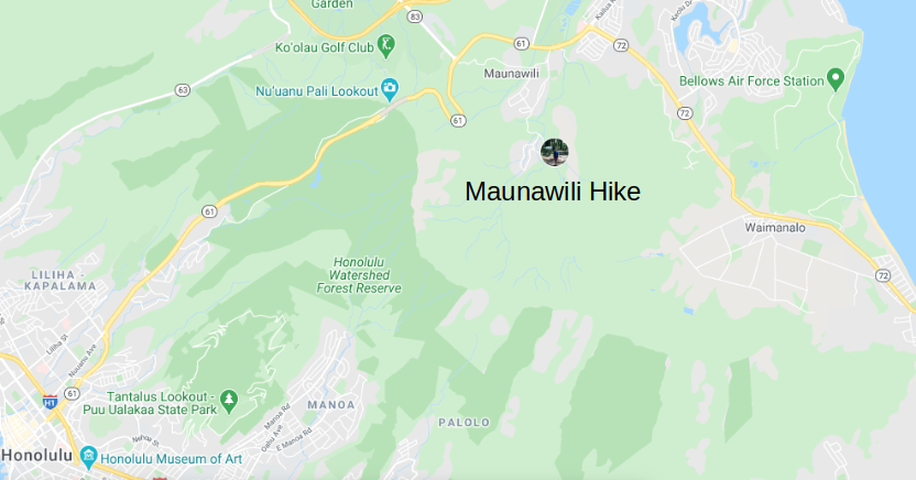
Day 3
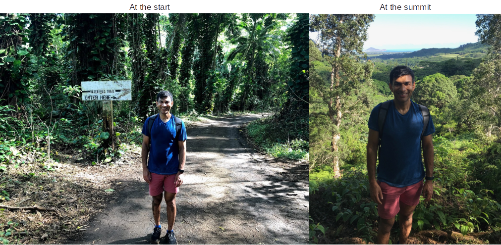
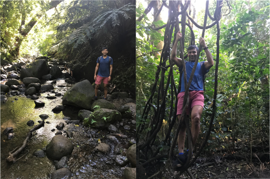
On day 3, we did a “waterfall hike” to the Maunawili falls, likely the muddiest hike I’ve ever done (until this point, because the my next two hikes were even muddier). The hike followed a dry but muddy stream-bed up and down through a forest leading to a summit and then descending down to a waterfall. We didn’t make it to the waterfall but turned around at the stream that would have led to the waterfall because we needed to be back at the house by 12:30 PM. It was Michael’s birthday and I had booked a kiteboarding lesson for him at 1 PM.
Typically hikes start in a park or in a rural/rustic area, however this hike started in a really nice neighborhood, full of lovely houses with well-manicured lawns surrounded by imposing lush green mountains.
Later, we went to 53 by the sea, a nice seaside restaurant with some gorgeous views of the water.
Day 4
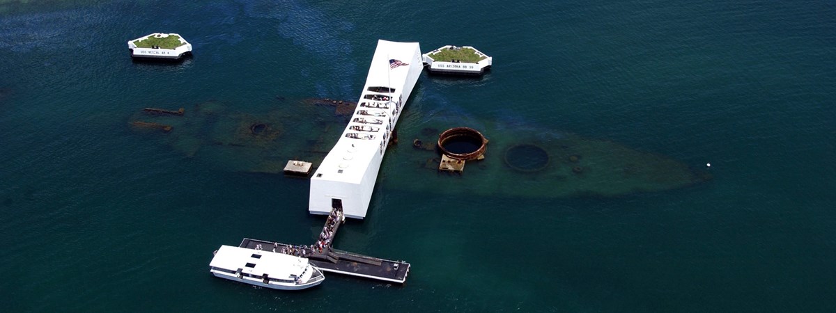
My legs were still feeling the hikes on the previous two days and it was also Mike’s birthday so we decided to take the day easy. We dawdled around until mid-day and then drove to the Pearl Harbor museum, a 30 minute drive from our house. Pearl harbor museum has 4 sections:
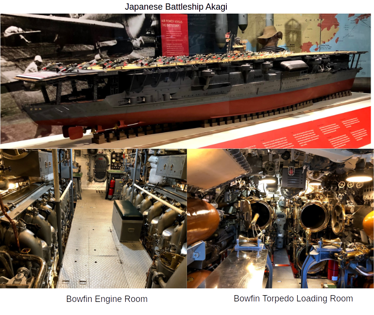
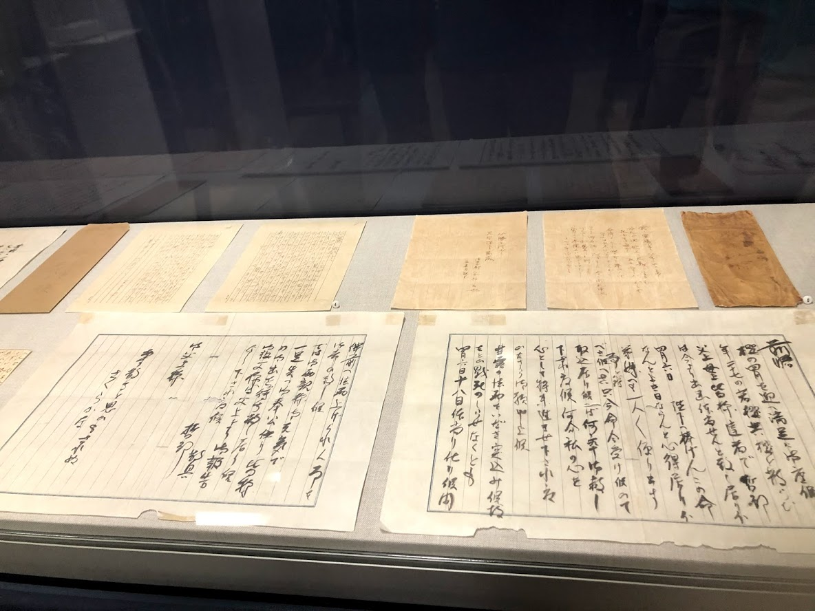
- Pearl Harbor National Memorial: Tells the story of how geopolitical tension between Japan and the US eventually led to the attack on Pearl Harbor on Dec 7 1941, a day that in the famous words of president Franklin Rossevelt will “live in infamy”. Some notable exhibits are models of the battleship Arizona, Japanese aircraft carrier Akagi and the hand annotated speech by FDR where he strikes out the word “history” and scribbles the word “infamy” in the sentence “a day that will live in history”. This section doesn’t require a ticket
- USS Bowfin Submarine Museum: A tour of the submarine Bowfin that served in the Pacific theater during WW2. It is cool to see the torpedo room where the torpedoes were loaded into the firing tubes, the two engine rooms each housing two V-16 engines and the sleeping quarters of the sailors. I was blown away by the sheer amount of equipment on board, specially all the instruments and dials. It must have taken a lot of training to operate the submarine! A fact I found interesting is that the submarine could operate submerged for only a few hours because it used batteries for propulsion while under water. It spent most of its time cruising on the surface under engine power when it could recharge the batteries. The submarine tour requires a ticket, and is worth getting one.
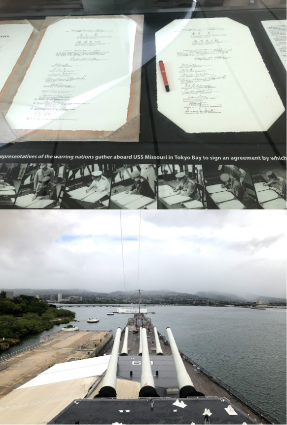
- Battleship Missouri Memorial: WWII finally came to an end on 2 September 1945 with the surrender of Japan on the deck of Battle Missouri. We toured Battleship Missouri on a separate trip to Pearl Harbor.
- USS Arizona Memorial: A platform erected on top of the Battleship Arizona, sunk during the Pearl Harbor attack. We didn’t get to visit this memorial.
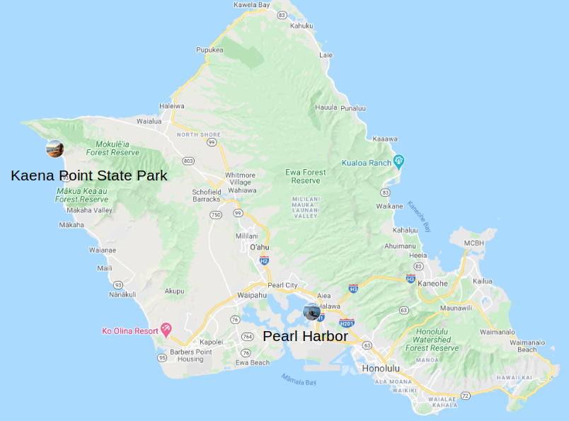
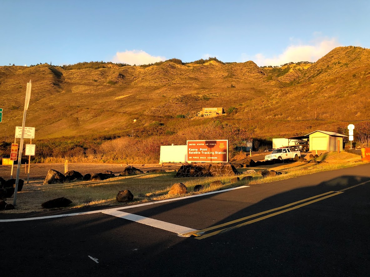
After Pearl Harbor, we drove along the North West coast to Kaena point state park. The North Western coast is drier and the mountains less lush because it falls on the leeward side of the mountains that run along the interior of the island and block the trade winds that blow from the North East. It also appears poorer than the rest of the island. We saw several poorly dressed people, decrepit cars and even some Trump campaign signs!
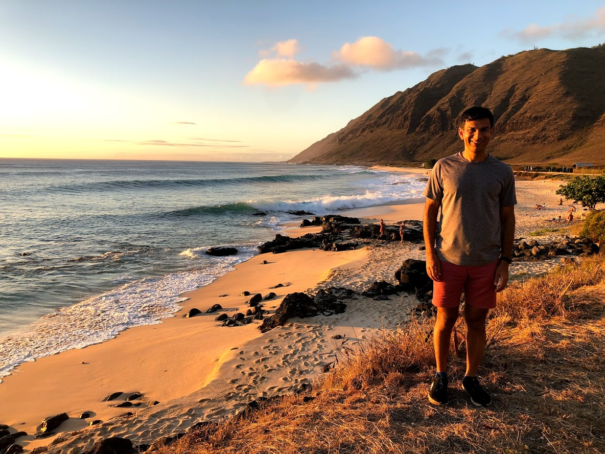
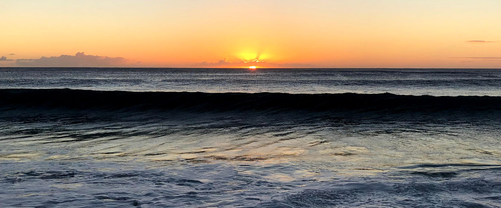
The setting sun bathed the mountain side in a gorgeous orange light. We saw some huge waves and a spectacular sunset!
Day 5
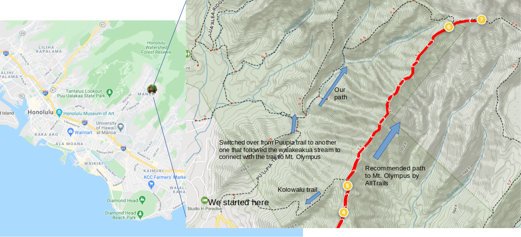
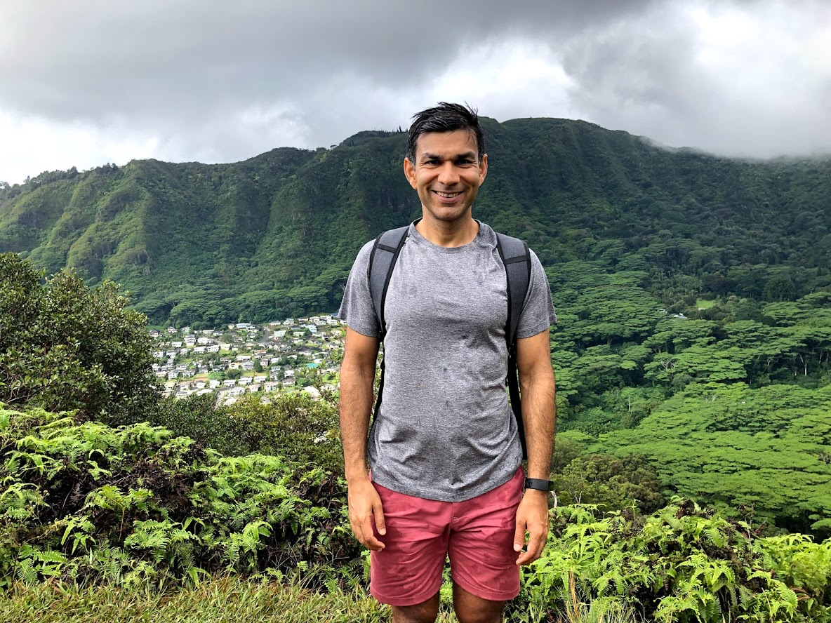
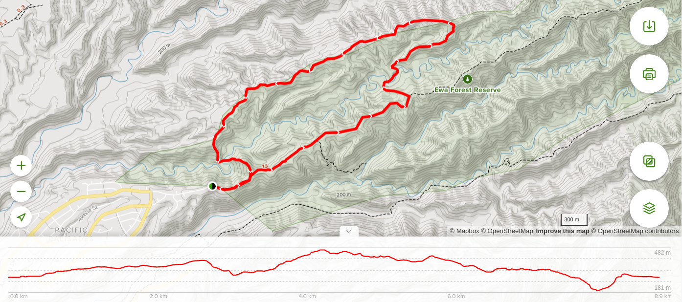
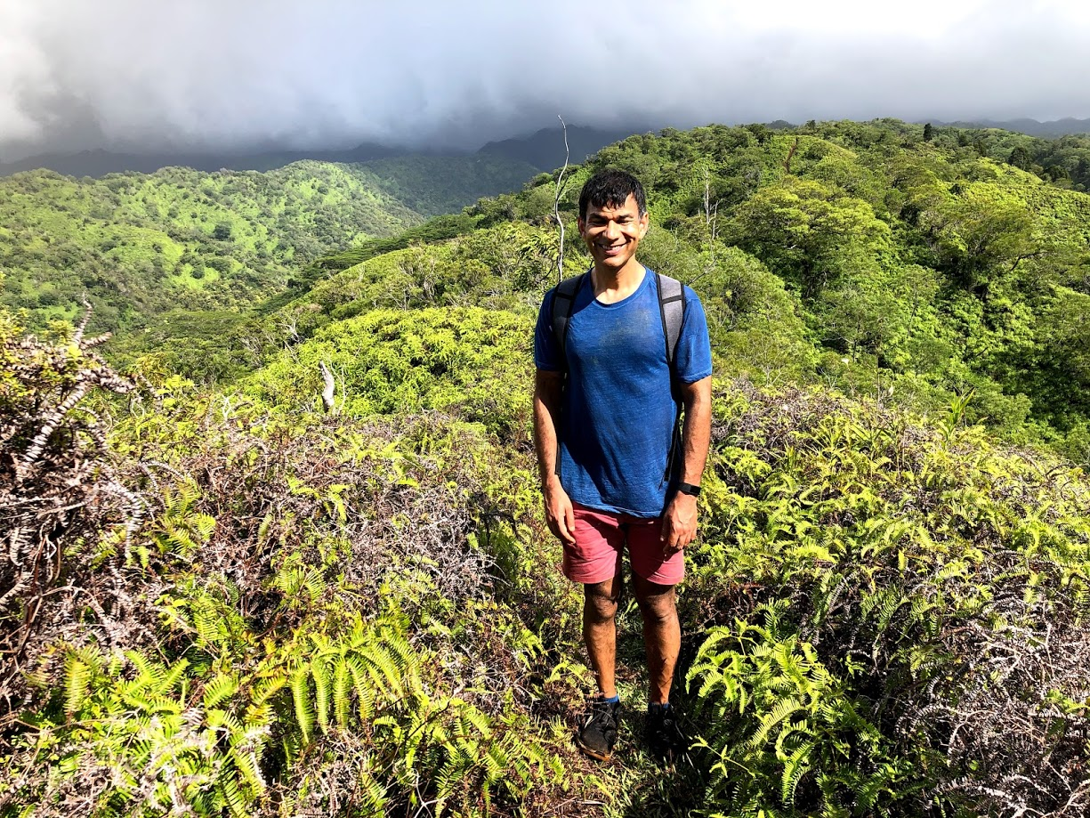
Day 4 provided a much needed break to my legs that were a bit sore from the hikes on Day 2 and 3. So on our fifth day, I was ready to do a longer hike. We decided to do the Mount Olympus Awaawaloa via Wa’ahila Ridge Trail, a 5.9 mile heavily trafficked out and back trail located about a half hour drive from Honolulu. The trail is rated difficult and is rating is well deserved.
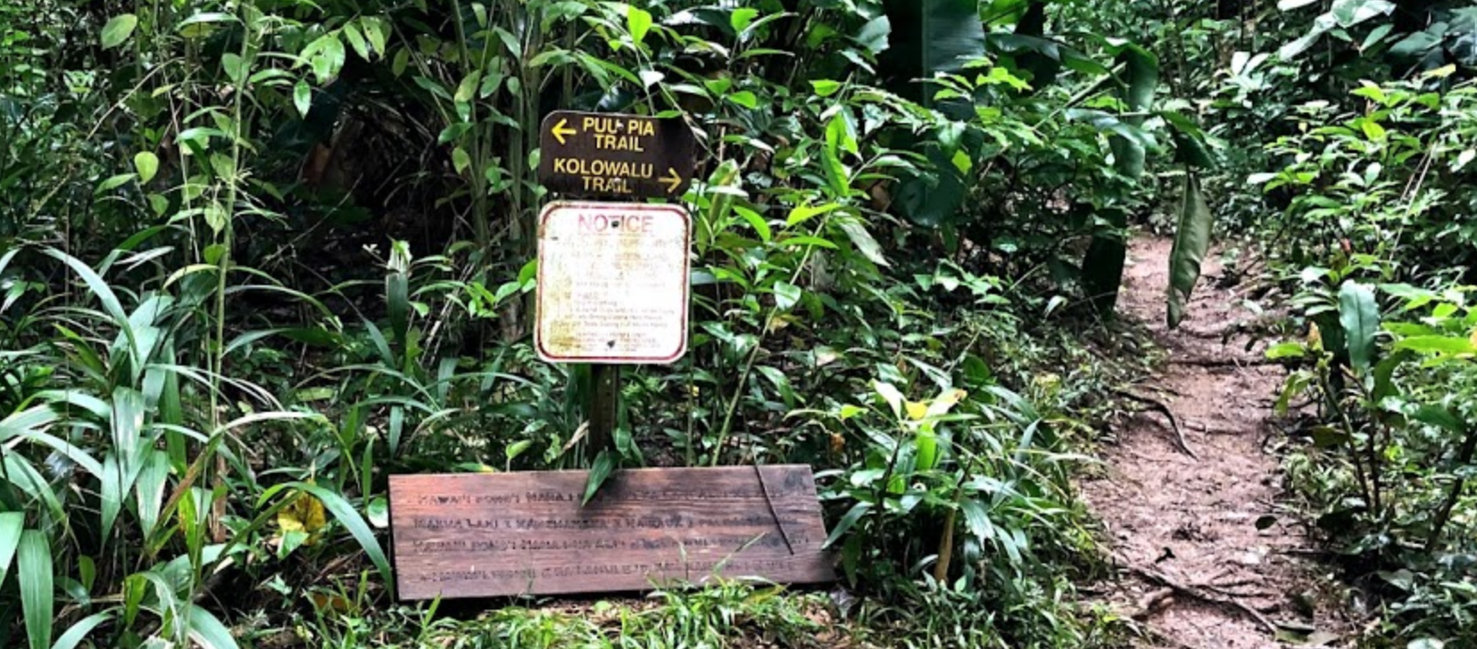
To convert the out and back trail into a loop, we decided to start at the Puupia trail, switch over to another trail that follows the Waiakeakua stream and then ascend up to meet the Waahila ridge trail. Then we would follow the waahila ridge trail to the summit and then turn back and follow the trail back to the Kolowalu trail which intersects the Puupia trail. See map below.
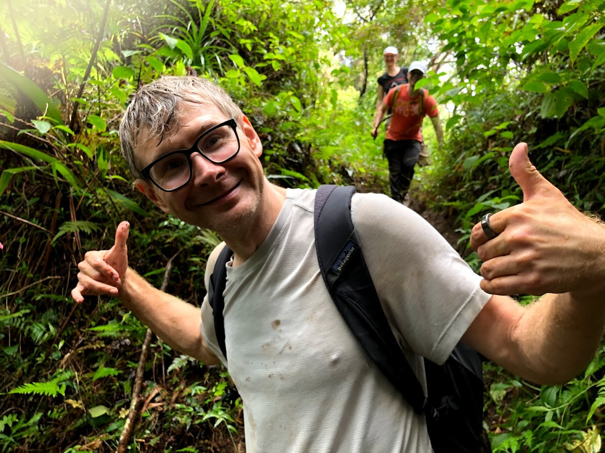
Although the weather forecast predicted a mostly dry day, we got hit by rain almost right after we started our hike. As I realized later, this is quite common, because the mountains have their own micro-climate and it can be raining and wet in the mountains when it is sunny and dry elsewhere on the island. The trail was very wet with puddles of muddy water scattered all along our way. The vegetation around us was thick and lush, very much like a rain forest. Tree roots crisscrossed our way forming a giant net that provided nice footholds to avoid stepping in the mud puddles and slipping on the extremely slippery ground.
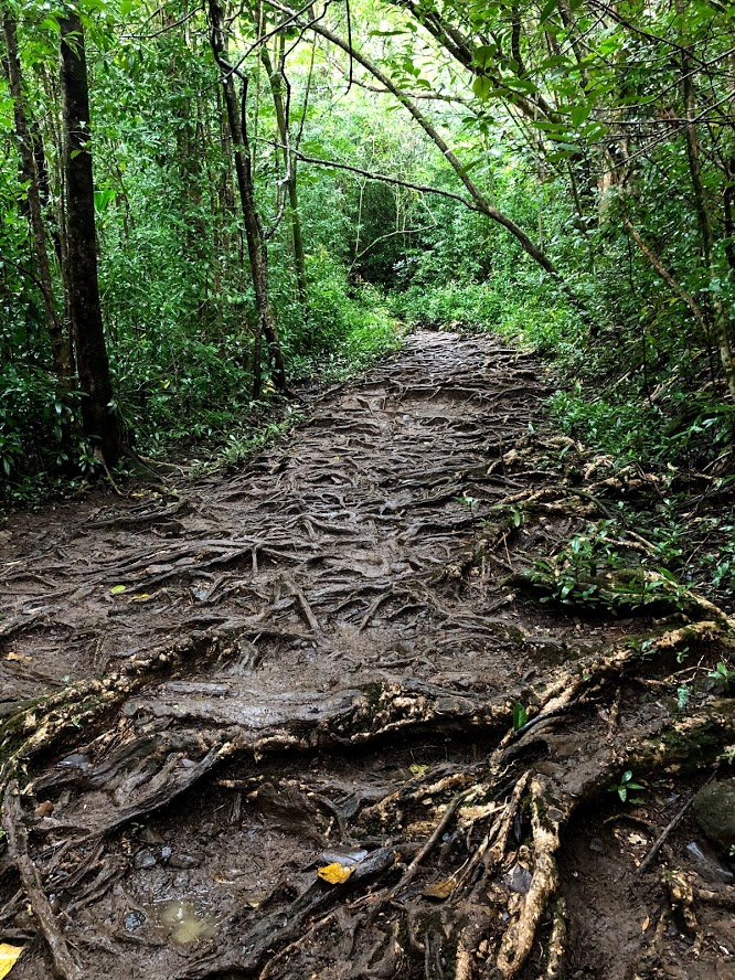
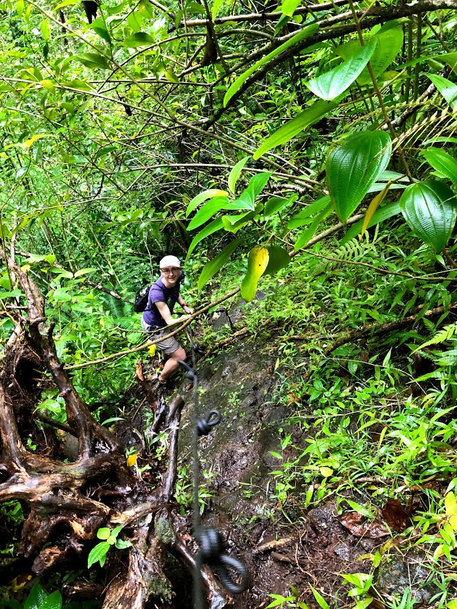
The descent from Puupia trail to the Waiakeakua stream was down a very steep and slippery path. There were ropes available to help descend some of the particularly steep sections. The tree roots spanning the path provided excellent handholds and footholds.
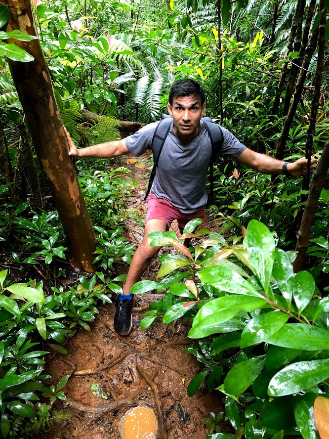
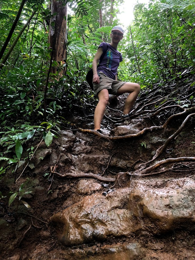
We followed the trail along the stream bed for about a mile. The trail ascended and descended and crossed the stream several times. There were ropes tied around tree trunks to help go up and down but the rain turned the ground very slippery and I slipped several times. The trail was also getting increasingly more difficult to follow because of the undergrowth.
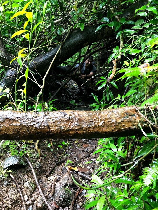
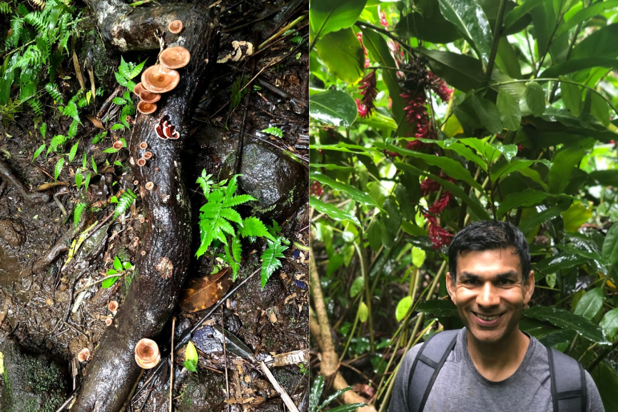
There were pink/orange ribbons wrapped around tree trunks every quarter mile or so to serve as trail markers, however due to the thick undergrowth, the trail was still quite difficult to follow. Unfortunately, after a while, we lost track of the trail completely. We went up and down the trail making sure we hadn’t gone astray, but after the last trail marker, we simply couldn’t find a way up. Plus, the rain showers were getting more frequent and the trail was getting wetter and dangerously slippery. After some agonizing, we decided to retrace our path back. Along the way, we saw several beautiful wild flowers and mushrooms!
Some tips for hiking in Hawaii:
- Be prepared for a lot of mud and slippery ground, specially if it has rained recently. Wear decent hiking shoes and be prepared for the shoes to get wet and muddy. Thankfully, Mike’s rented house had a great washer and dryer.
- Alltrails has excellent information about hikes in Oahu with detailed trail maps. Download their app and an offline map of your trail so you can see where you are on the trail in areas where internet connection is spotty or unavailable.
- A trail marked hard on Alltrails actually means hard. Be prepared for very steep ascents/descents using ropes, slippery ground, wading through undergrowth and narrow, hard to follow trails. That said, hiking through the rain forest surrounded by lush green vegetation, listening to the sound of waterfalls and birds is an incredible experience.
Day 6
It was cold and windy and rained nearly non-stop all day so we decided to do some indoor activities. On our trip to Pearl Harbor on Day 4, we had missed seeing the sunken battleship Arizona, USS Missouri and the Aviation museum, all of which are on Ford island, which is a military base and requires getting a ticket. So, today we went back to Pearl Harbor and bought tickets to USS Missouri and the Aviation museum. We wanted to see Arizona as well, but tickets are difficult to get.
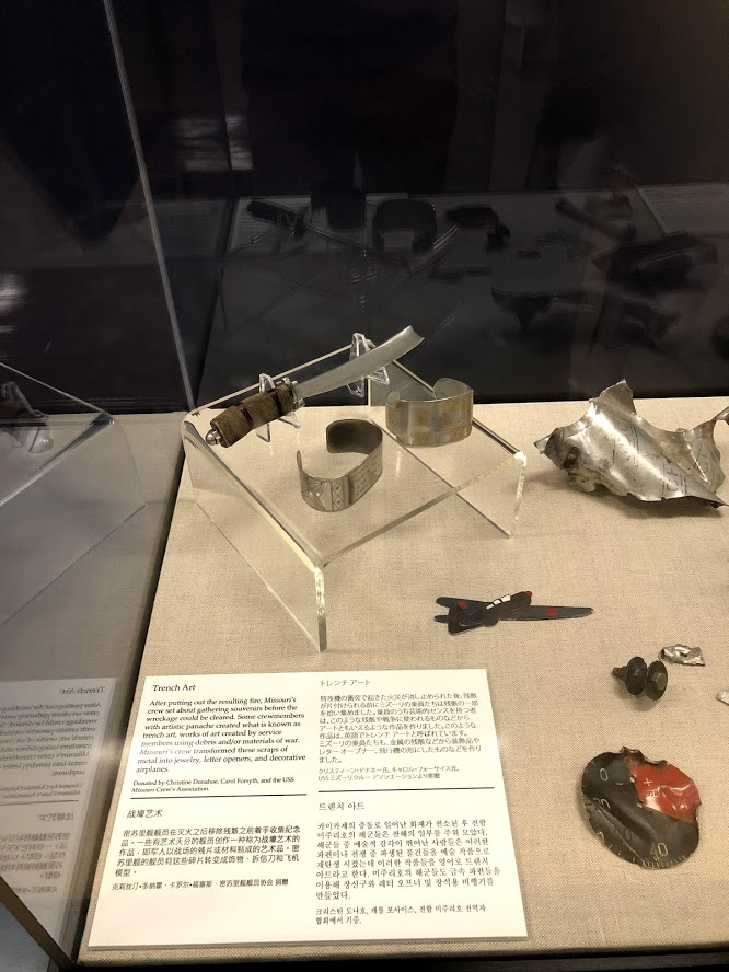
The tickets were almost $60, so a bit pricey. The aviation museum only has a few Japanese and US WW2 plans, and unless you are a hardcore aviation enthusiast, I don’t recommend it. The exhibit I found most interesting were the letters written by Japanese Kamikaze pilots to their family shortly before they embarked on their final flight.
In a reminder that no matter how challenging the times, human ingenuity, humor and creativity always finds an outlet, another exhibit showed the works of art, decorative and household items created from the scraps of metal from the debris of the Kamikaze planes by the crew onboard the ships which were the target of the Kamikaze attacks
The USS Missouri is more interesting, though most of the tour goes through the living quarters and dining/entertainment areas of the sailors, so not particularly exciting. The USS Missouri is best remembered as the site of the surrender of the Empire of Japan, which ended World War II on Sep 2 1945.
Day 7
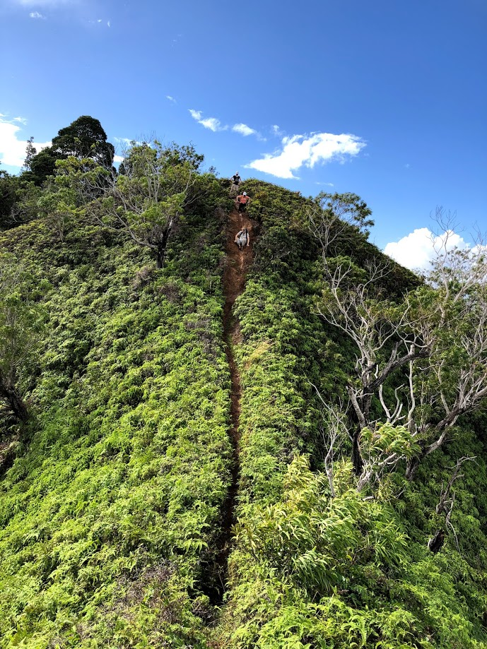
On day 7, we did the Illiahi Ridge trail, a 5.5 mile loop about 40 minute drive from Honolulu, not far from Pearl Harbor. Having learnt our lesson from last time, we followed the AllTrails hike map, including the recommendation from others to do the hike clockwise to go through the hard sections toward the start of the trail.
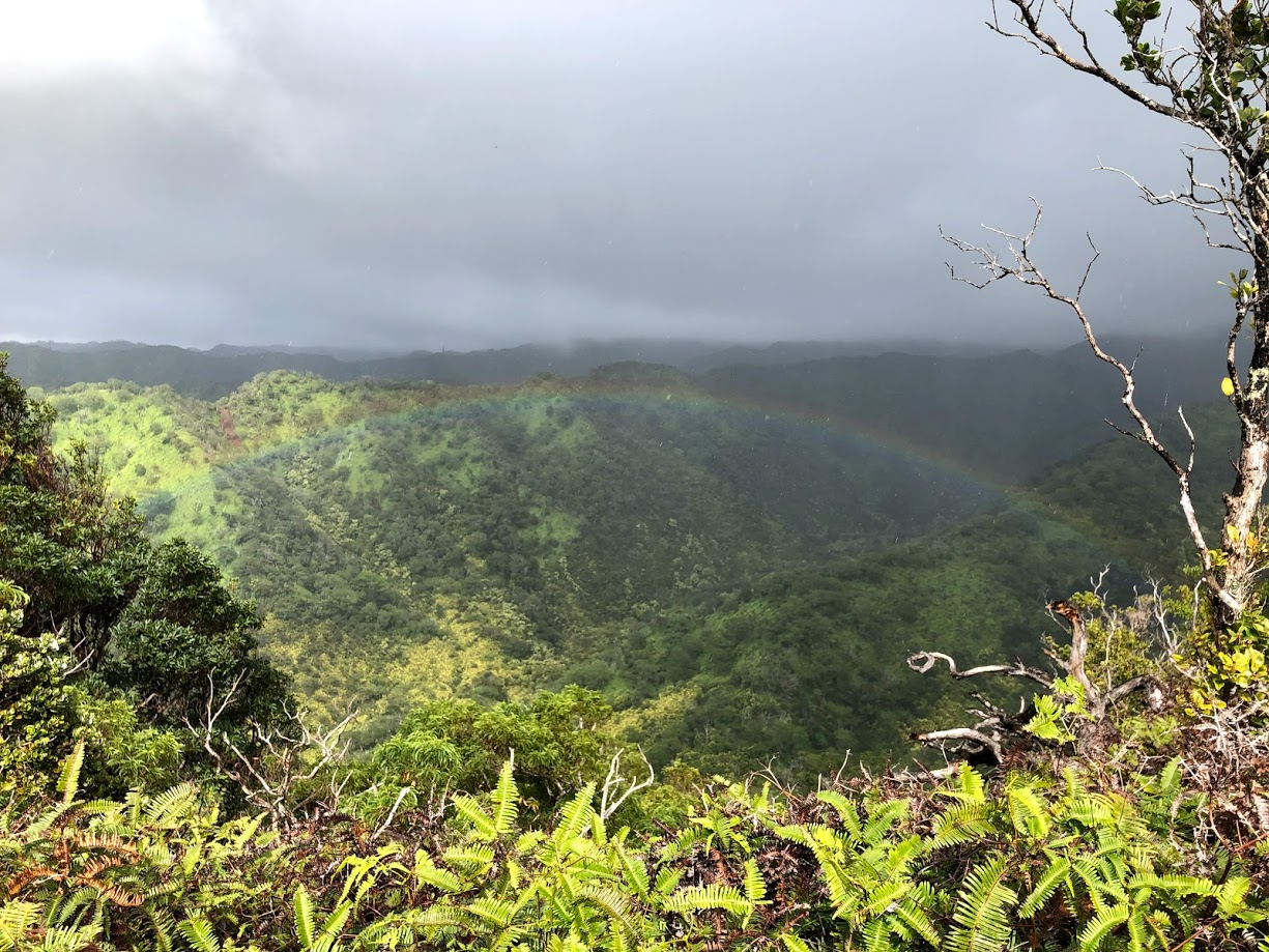
Similar to some of the other trails, the trail head of Illiahi ridge trail is smack in the middle of a nice residential neighborhood and was easy to find. The first quarter mile or so is along a lightly paved road and then we took a sharp turn to the left to descend rapidly down to a stream followed by a rapid ascent to a ridge line. We followed the ridge for 3 miles or so taking in breathtaking views of the nearby mountains, including several rainbows. The top elevation along the hike is roughly 450 meters. Shortly after hitting peak elevation, the trail makes a sharp turn, follows another somewhat lower ridge line back and descends back down to the stream. It crosses the stream, makes a sharp ascent up and continues back to the starting point.
It rained off and on throughout our hike and the ground was very muddy and slippery. Some of the descents were very steep and we had to butt slide our way down. On a couple of sections, ropes were available to help with the ascent and descent. The trail gets very overgrown with sharp shrub branches poking in from both sides, so wearing sturdy hiking pants is highly recommended. I wore shorts and my legs got very scraped up. I also recommend downloading a trail map which can be used offline. It is easy to lose the main trail and get on one of the side trails (happened to us twice). It is good to check every quarter mile or so that you are following the correct trail. You get a good GPS signal most of the trail, but the data signal can be spotty, particularly in the valley. So it is good to have a trail map that can be used offline.
Some of my friends are relatively slow hikers, so it took us around 5 and half hours to finish the hike. The hike is rated as moderate on Alltrails, but it should be rated hard in my opinion, specially if you do it on a wet day. Overall, I recommend the hike, but make sure you are in good shape, and ok with getting muddied up.
Some pictures from the hike:
In the evening we went to Il Lupino, an Italian restaurant in downtown Honolulu. The restaurant has nice patio seating, but the food and drinks were average at best. I wouldn’t recommend it.
Day 8
I was a bit sore from the hike the day before, so we decided to take it a bit easy. My friend Agnes was leaving for Baltimore later that day and wanted to visit the Bishop museum, a museum about Hawaiian culture and Polynesian history and go snorkeling in Hanauma bay, a famous snorkeling spot because of its high fish population, calm shallow water, and white sand. We had also booked an e-foiling lesson as a birthday gift for my friend Michael. We decided to do the museum in the morning and the e-foiling lesson and snorkeling in the afternoon.
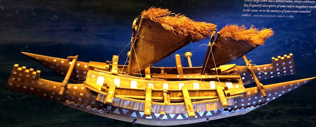
At Bishop Museum, I spent most of my time in the “Kahili room”, that features ornamental feather displays along with a nice timeline of Hawaiian monarchs from Kamahameha the First to the last Hawaiian monarch, queen Liliuokalani and a multistory hall about Polynesian history and culture. It is incredible to think that the Polynesians never discovered metal, or timekeeping and navigation tools such as compass; yet could travel to and settle remote islands separated by thousands of miles of open ocean in wooden canoes. The museum provides some interesting information about how they built their canoes and their navigation techniques. The navigation techniques can be summed up as stars, seas, winds and birds.
Stars: The position of prominent stars at sunrise and sunset and the paths traced by the stars depends on the viewers position. The Polynesians memorized these paths, recorded them in their folklore and prepared visual aids using mats and stones
Winds, waves and birds: During the day when stars were no longer visible and on cloudy days, the Polynesians relied on winds, movement of waves and homing birds. For example, waves are shorter and steeper and have a breaking crest closer to land, whereas out to sea, waves are felt as a slow undulation. The flocking patterns of migratory birds provide cues about how far is land. Fairy terns, for instance, fly no farther than 20-30 nautical miles (35-55 kilometres) from land.
Here’s a nice article about Polynesian navigation and their settlement of the Pacific.
After Bishop museum, we went to take our e-foiling lesson. Foil boards are the latest trend in surfing and kitesurfing. Foil boards feature a dual set of wings mounted on a shaft underneath a surfboard similar to a regular surfboard. At start, the wings are submerged into the water and the surfboard is riding on the water surface. As the board starts moving (by the action of waves or a kite), the wings start generating lift, eventually pushing the board out of water. Once the board is out of water, wave and water resistance is significantly reduced, enabling the rider to glide smoothly across the surface. We saw several surfers riding a foil board right behind our house. It looks magical!
e-foil boards have a small motor and propeller powered by a lithium ion battery attached to the wing, letting riders foil on calm water (such as on a lake or river). The motor’s speed can be adjusted using a hand-held controller which communicates with a controller on board using bluetooth. Once the board is going fast enough, the rider can pop out of the water with a slight adjustment of weight. The tricky part is maintaining your balance once the board pops out. I was able to stand on the board and make S turns without issues, but as soon as the board popped out, I would lose my balance and fall into the water. It will probably take a few attempts to get the timing and balance right. It was a fun experience though and we all enjoyed it.
After the lesson, we went to Hanauma bay state park, a renowned snorkeling spot. However, we found that the park is closed on Monday and Tuesday due to Covid restrictions. My friend Agnes was very disappointed because she was departing Oahu later that day. I will definitely check out this park before I leave.
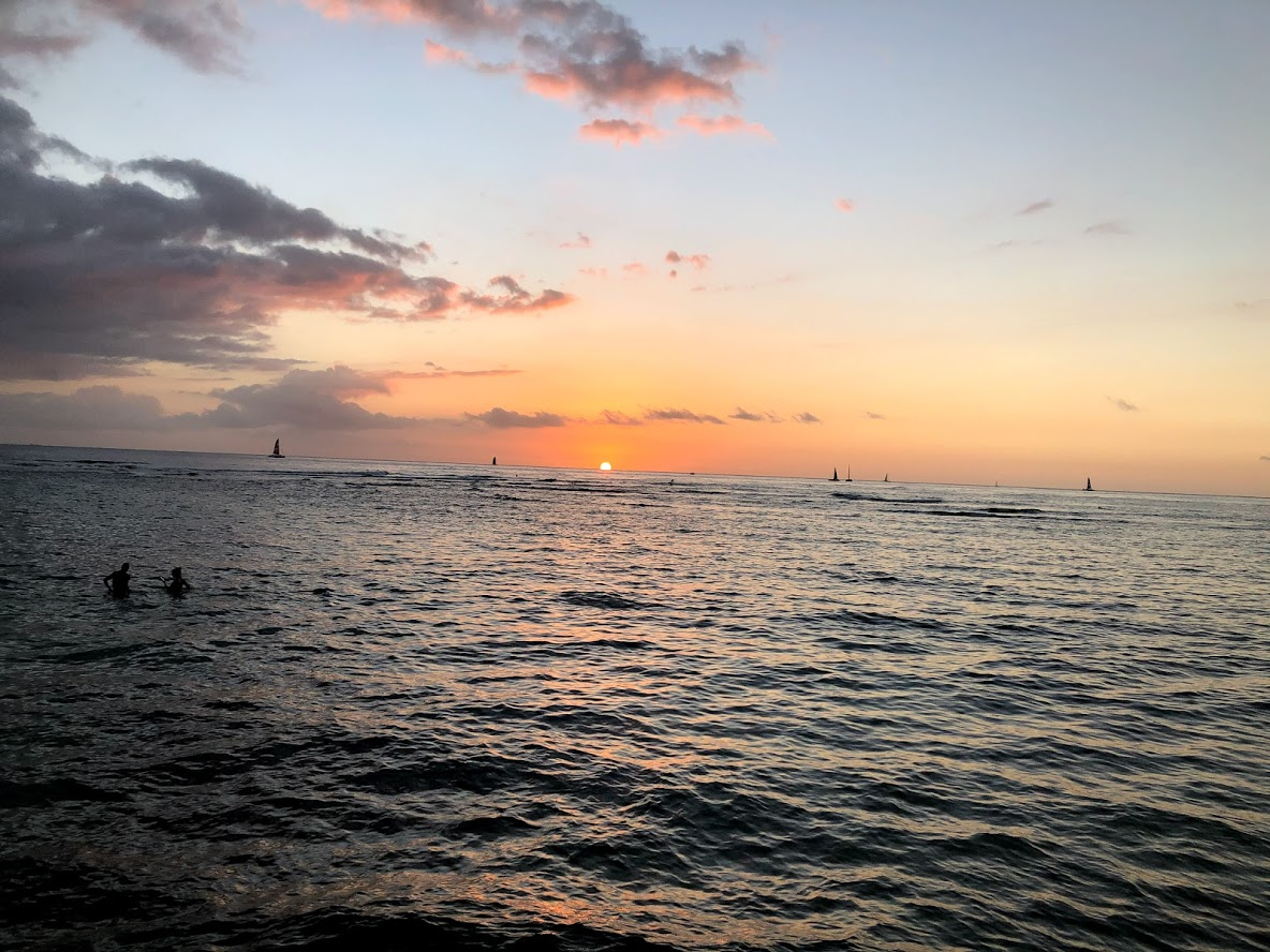
In the evening, we were treated to a gorgeous sunset!
Day 9
On day 9, I just had a super chill day. Read, finished some work, went kayaking right behind our house..
Day 10
On Day 10, thanks to Mike’s generosity, we all got to ride on a chartered flight flying south east over the islands of Molokai, Maui, Big Island and back. Along the way, we took in gorgeous views of the lush green forests and waterfalls on Maui, Volcanoes national park on Big Island and mount Haleakala on Maui. Some annotated photos from the flight are shown below.

Here’s an amazing video of flying over Haleakala on our way back:
Day 11
It was the last day of the year and what better way to end it than going hiking and kiteboarding! In the morning, I did the Diamond head hike (which I had missed earlier because the Diamond head park, where the hike starts was closed), a 2.9 km very popular out and back trail located right behind our house. The hike starts at the parking lot of the Diamond head park. During my trip, the park was only open Thu-Sun, so check the park hours before your visit. The trail is paved most of the way and easy to follow. About 2/3 of the way up, it goes through a tunnel followed by a set of steps which lead to a summit with nice views of the Honolulu skyline. I was able to do the out and back hike in ~40 minutes.
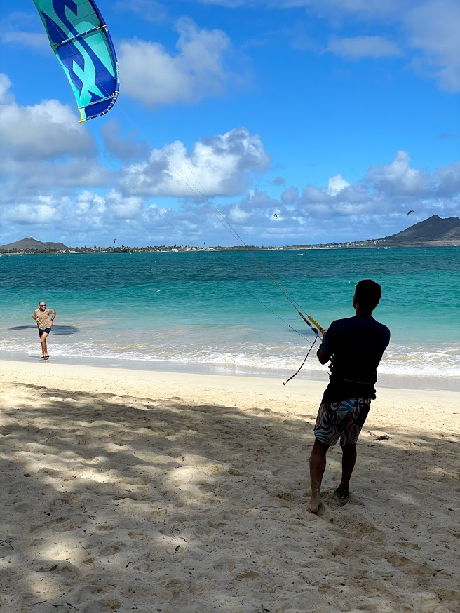
After the hike, I drove to Hanauma bay for snorkeling, however the Hanauma bay park only allows limited number of people and I was deterred by the long line of people waiting to enter. It was windy out, so rather than waiting in line to snorkel, I drove out to Kailua beach for a kitesurfing session. I had also booked a series of kitesurfing lessons for Michael with Felipe, a local kiteboarding and foiling instructor and his kite lesson was on this day as well. I had brought my 12m F1 Bandit and harness from DC in my check-in luggage, but not a board. So I arranged to pick up a board with Felipe (which at $35 a day is a lot cheaper than renting a kite).
The GPS coordinates of the beach are: 21.398389, -157.728889
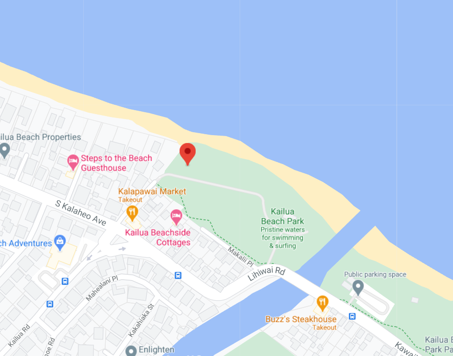
There is a parking lot right next to the kiting location, but it was full when I arrived and I had to wait a bit to find a parking spot. But hey, it was windy and the sight of loads of kites and kiters brought a huge smile to my face 🙂
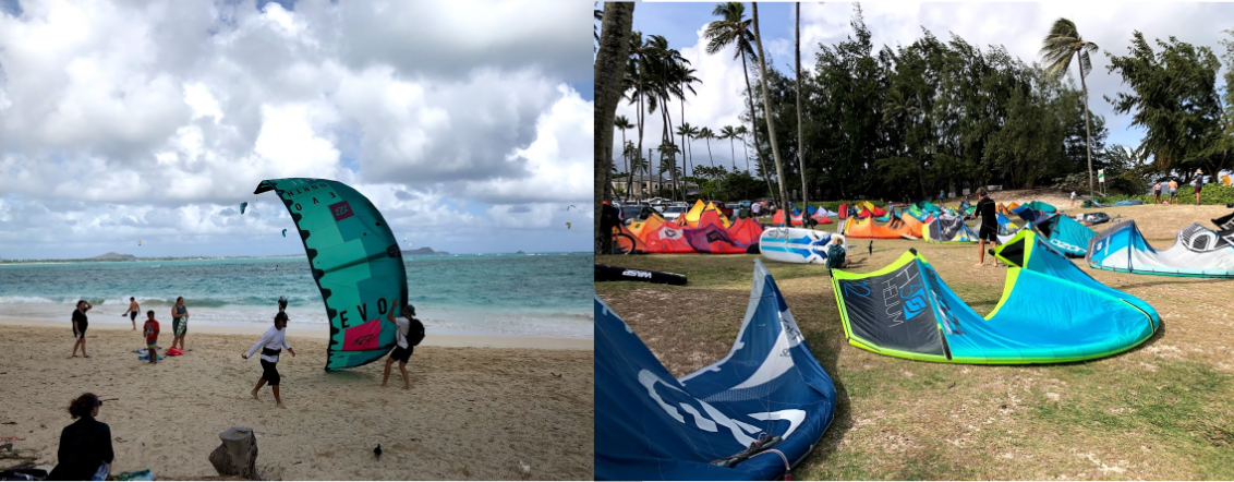
The beach is long but narrow and there are palm trees not far from the water so one has to be careful while launching and landing. On two out of three days I kited in Oahu, someone landed their kite on a tree by the water (same tree both times)!
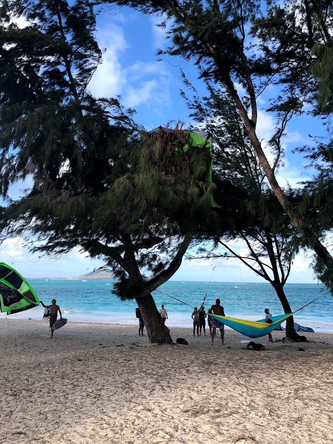
It turned out to be too windy for my 12m, so I rented a 9m Bandit from Mike’s instructor, in addition to the board. I was a bit reluctant to spend the extra money to rent a kite, but then I reminded myself how much I hate being overpowered! The 9m turned out to be perfect. It was super fun coming in riding the incoming swell and cutting through the waves on my way out. I was riding toe side, doing jumps and load and pops like a champ! :-). The area is very scenic with blue water, white sands and splendid views of nearby islands and mountains. Felipe
was kind enough to record a video for me 🙂
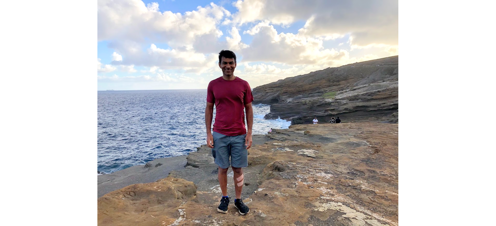
On my last run, I got hit by a wave as I was strapping out of the board and scrapped the skin around my left shin. So you’ll see a couple of large band-aids around my left shin in the pictures from now on.
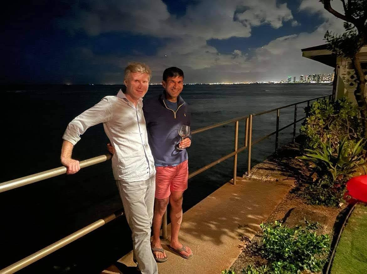
Later in the day, Mike had a few of his friends over for a NYE celebration. I was a bit tired from all the activities and went to bed shortly after midnight. It was good to bring 2020 to a close and usher in 2021, hopefully a much better year!
Day 12
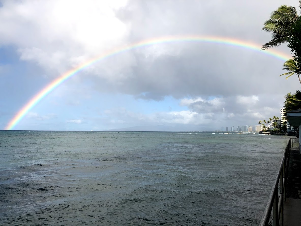
On the first day of 2021, I woke up early to be greeted by one of the most vivid, bright and complete rainbows I have seen.
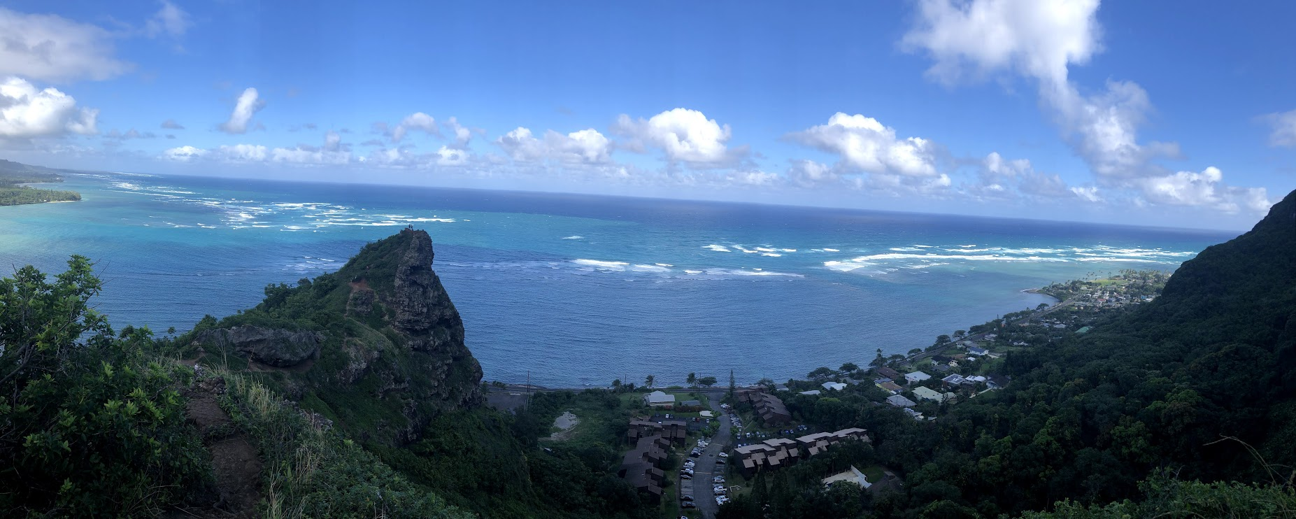
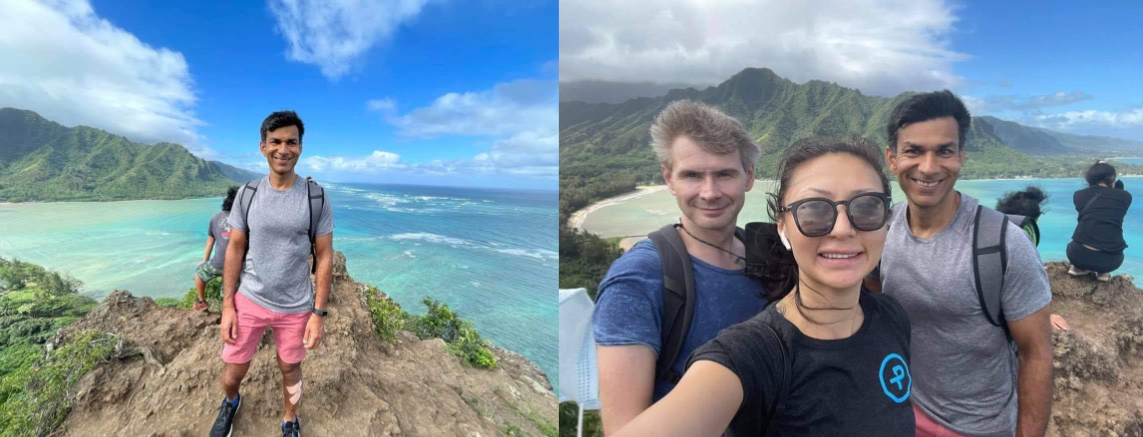
I took it easy the first part of the day. Made some coffee, read, went kayaking for a bit. Later, Mike, Aya and Mike’s friends Henry and Jonathan who had stayed over from the NYE party the day before did the Crouching Lion trail, a heavily trafficked, short (0.6 km) but steep hike on the North East side of Oahu. I highly recommend this hike, it is steep, but offers breathtaking views of the surrounding area. It hadn’t rained much that day so most of the trail was quite dry. However other hikers on Alltrails report that the trail can get quite muddy after a rain, so go prepared. Ropes are available to help scale some of the steeper sections of the trail. I recommend hiking shoes with a good grip for this trail.
On the way down, we saw a couple of guys trying to drive small remote controlled trucks up the trail 🙂
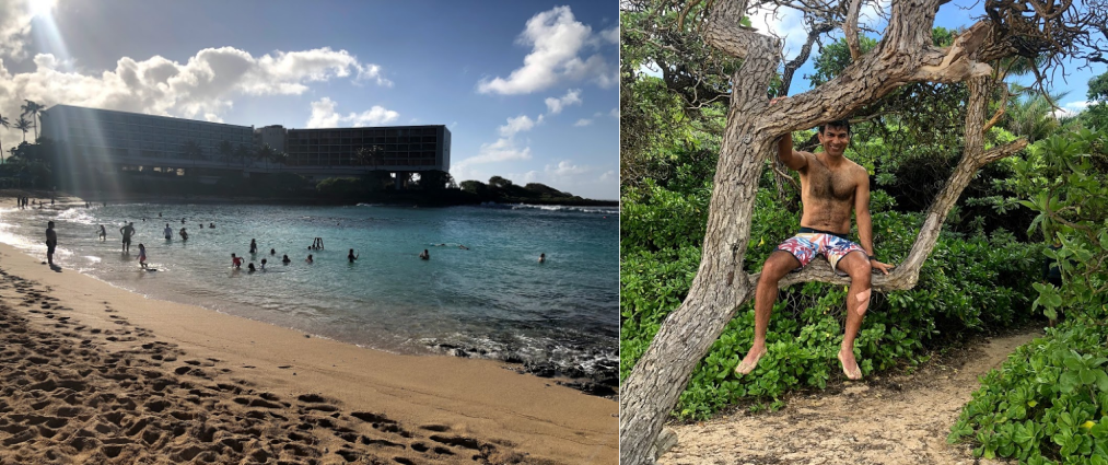
After the hike, we went to Kuilima bay for snorkeling. Kuilima Cove is a sheltered and serene snorkeling spot tucked beside the eastern edge of Turtle Bay Resort on Oahu’s North Shore. The surrounding area is part of the hotel property so it is well kept. Unlike Hanauma bay, Kuilima is one of the lesser known beaches and there was plenty of space for us to lay down our beach towel. Since Kuilima bay is part of the hotel property, I was concerned we may not be able to park nearby, but there was a parking lot with public access and plenty of spaces a short walk from the beach.
It was quite windy that day and the waves were pretty big. Although the cove is sheltered by a reef which blocks most of the waves, some of the big ones still make it through and stir up sand making the water murky. This didn’t make for ideal snorkeling conditions although I had a good time and saw many types of fish of different sizes, color and patterns.
I also saw several dirt trails near Turtle Bay which looked ideal for a mountain bike or a hybrid. Next time I visit Oahu, I’ll consider renting a bike and check out some of the mountain bike trails. Biking seems to be a popular activity; I’ve seen several road and mountain bikers.
After snorkeling, we stopped to get tacos at some food trucks a few miles away. On the way, we enjoyed the sight and sound of huge waves crashing into the shore. The north shore of Oahu is less developed and more chill than the area around Honolulu. We drove by several roadside fruit shops, food trucks and such. With the huge waves, it seemed to be a surfers paradise although we didn’t see any surfers. It could be that the waves break too close to the shore to be safe for surfing. If you have the time, I definitely recommend spending an evening driving around the North coast.
It was nearly an hour drive home and I was pretty tired. It was around 8 by the time we got home, I read a bit and then decided to take a nap. Ended up sleeping for 3 hrs! Finished some work after I woke up and then went to bed again. It was good to get 10-11 hours of sleep that night, my body definitely needed it.
Day 13
On Day 13, it was windy again, but not as windy as the previous two days. The wind speed looked within the upper range of my 12m Bandit. So I got up early, made coffee, sat in the front yard and enjoyed the gorgeous sight of sunlight slowly filling in and lighting up the waters around the house and the sound of the waves crashing on the shore. Around 9, I left the house to first visit Hanauma bay (the snorkeling cove) again to see if the line was any better that morning. Alas, the line seemed just as long as last time. I wavered for a bit if I should suck it up and join the line, but then decided against it. I enjoy snorkeling, but like kitesurfing a lot better 🙂 So I drove on to Kailua beach again, met up with Felipe, rented a board and went out on the water. The wind was great, but definitely on the higher end of my 12m kite. I was kiting fully depowered, which makes it super easy to stay upwind, but also makes the kite slow to turn and respond. About 15 min into my session, I landed a jump wrong and got splashed with a huge wave of water which knocked out one of my contacts. To add insult to injury, I got stung by a vicious jelly fish a few min later. The jelly fish sting felt like a sharp, shooting pain around my right shin (the site of the bite) which slowly made its way up the leg. It is an experience best to be avoided. I hung in there for another 15 min or so, but losing the contact lens was messing with my depth perception and the pain from the jelly fish sting wasn’t helping.. so I cut the session short and wrapped up the kite.
After I got back home, I took a couple of Tylenol to help numb the pain and took a nap. Woke up around 3 and felt much better so I decided to fit in another short hike. I drove to the north western part of Oahu to do the Puu-o-Hulu trail
Day 14
Day 14 was the last day of my trip. I had planned to take it easy, but it was windy again so I decided to do another session of kiteboarding. This time Michael’s friend Aya also joined me to go to Kailua beach and made some nice videos of me kitesurfing. I put together sections from her clips to make the video below. The conditions were nearly perfect. Smooth wind, nice swells, not as crowded as on the previous days, likely because many of the tourists in town were departing that day. No jelly fish stings or contact lens mishap this time!
After kitesurfing, we got a big burger at a sandwich place near the beach and drove back home around 2. Aya’s flight was at 5, so she had to pack and leave for the airport shortly. I worked on this blog for a bit, gathered my stuff and went to see Halona Blowhole near Hanauma bay, my last outing of the Hawaii trip. The Halona blowhole is a rock formation created by lava tubes. When the surf conditions are right, the blowhole shoots water up to 30 feet in the air.
I didn’t find Halona blowhole all that exciting. There is a small cove nearby with a jumping off point and a swimming area that looked nicer!
That was it! I packed, had a parting drink with Mike, Leo and Yulia, gave everyone a big hug and drove to the airport. Finding the Enterprise car rental return turned out to be bit of an ordeal. I drove to the rental location near the airport (from where I had rented the car) to drop the car off, but to my dismay, found the location closed. There wasn’t a key drop-off anywhere either. I called Enterprise, but their customer service call center was closed as well. After driving around in a rapidly increasing state of panic, I noticed a rental car return area in a big parking lot for all the other car companies (Hertz, Sixt, National etc) except Enterprise. I drove up to the Hertz rental return to see if they could help me. They informed me that I could return my car at National, because National and Enterprise are part of the same parent company. So I drove up to National and was quite relieved (and also very mad) that I could indeed return the rental car there. I gave them an earful about how this was so confusing and I could have easily missed my flight had I not arrived at the airport 3 hours before my flight. They said there is a sign near the Enterprise rental return pointing people to National, however I definitely hadn’t seen any sign.. anyhow they promised to post a bigger and more conspicuous sign and also gave me some money off the rental..
The flights back were full but otherwise uneventful. It’s been a couple of days now that I’ve been back.. definitely a bit jarring to be in 40 degrees weather, in the thick of national politics (Trump supporters stormed the Capitol today and there is a curfew in place in DC and NoVA!), quite a far cry from the perfect temperature and carefree atmosphere of Hawaii! Anyhow, some amount of contrast makes one appreciate the good things even more 🙂
Hope you enjoyed reading this blog and found it informative. Post a comment if you did!
compiling such amazing & exhaustive coverage of each day activities is highly appreciable.
I really enjoyed this post! Full of details, hopefully I will visit Hawaii some day. Now there are several restrictions for travel in Argentina so I’m having a staycation. Glad to see you’re a blogger, I have a blog as well. Have a great year Ankur!
Best,
Magdalena.
Thanks a lot Magdalena!
Great trip summary! Very helpful and full of itinerary options. Thank you!